
Official websites use .gov
A .gov website belongs to an official government organization in the United States.
Secure .gov websites use HTTPS
A lock (
) or https:// means you’ve safely connected to the .gov website. Share sensitive information only on official, secure websites.
Cosumnes Community Services District
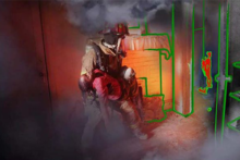
Augmented Reality Emergency Response System
4th place - $5,000 Prize
Multi-sensor based, indoor positioning technology to simulate a first responder emergency situation through a wearable SMART device.
About the Team
Team Members: Kirk McKinzie and Cosumnes Fire Department
The Cosumnes SMART Fire Department concept is focused on providing community risk reduction by leveraging current and near term technological solutions to provide public education and awareness, firefighter mixed reality training and augmented cyber-physical enabled emergency response mitigation. The platform is being designed to meet the mission of the Cosumnes Services District Fire Department (CSDFD), which includes “exceeding expectations at all times.”
Captain Kirk McKinzie is the project concept designer who brings 29 years as an emergency responder and nearly a decade in 360/3D forensic technology to the idealistic platform construction. His work is focused on saving lives through SMART fire and life safety systems. His vision is to use Virtual, Mixed and Augmented Reality (VR, MRX and AR) to provide public education, fire prevention awareness, first responder training and situational awareness during emergency response. He is involved with collaborative development of 3D remote sensed point clouds, BIM, computational fluid dynamics, gaming platform applications, haptic touch, digital scent, computer vision, coupled with relevant and actionable multi-sensor fusion; for a cyber physical HUD enabled “Iron First Responder.”
The Solution
Captain Kirk McKinzie’s Augmented Reality Emergency Response System proposal was largely based on a wearable SMART device that projects an augmented reality for the user. It’s an interesting mix of virtual object creation using 360-degree cameras and VR environment navigation. The Cosumnes team focused on operational planning, execution and safety for first responders using the critical requirements that come from Location-Based Services(LBS), to include indoor positioning, navigation and mapping into wearable devices and real-time platforms. The concept was focused on community risk reduction by leveraging current and near term solutions to provide public education and awareness, firefighter mixed reality training and augmented cyber-physical enabled emergency response mitigation. They suggested that Simultaneous Localization and Mapping (SLAM) techniques would be required given the challenging requirements of public safety LBS (i.e. distributed positioning and mapping, optimizations for impaired communications). SLAM uses vision, rangefinding, and/or inertial sensors to track motion of the device and map the environment simultaneously. The advantage of these techniques are that they are accurate, fast, and require no prior knowledge of the environment. The proposal addressed, in part, the issue of evaluating usability of new technologies through human testing. It also addressed the requirements of physical space elements, metrics and data that would be utilized in the measurement environment.
Key Features
- Indoor positioning trackers and 360 degree video cameras that move through actual, physical buildings to be used together with the collaborative mapping framework to efficiently construct 3D maps of the environment.
- The test platform would use currently available mobile devices, integrated into SMART helmets and goggles. The SMART helmets/goggles would display an emergency scenario digitally on the faceplate of the helmet/goggles to correlate with LBS data, record POV video, and show users how a fire may potentially propagate.
- The positioning system/platform would be able to precisely track and position personnel and/or assets in terms of latitude, longitude, altitude, and orientation.