
Official websites use .gov
A .gov website belongs to an official government organization in the United States.
Secure .gov websites use HTTPS
A lock (
) or https:// means you’ve safely connected to the .gov website. Share sensitive information only on official, secure websites.
Urban Test Bed Measurements
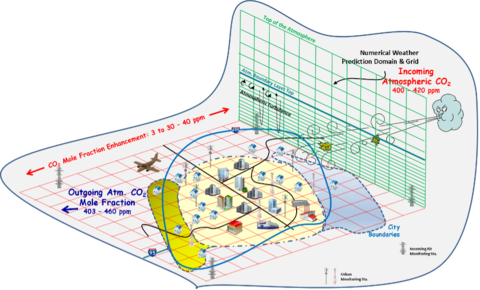
Cities and metropolitan areas are complex, comprised of many types of human activities. Tower-based observing networks are used to measure atmospheric GHG concentrations and perform analyses that translate concentration measurement data to emissions data. These analyses use numerical weather prediction and dispersion models to transport both incoming GHGs and those emitted within the city through the atmosphere. Analyses of this atmospheric data combined with spatially explicit emissions models provide a means to quantify urban emissions with fine spatial and temporal precision.
NIST is engaged in research to improve measurement of greenhouse gas emissions in areas containing multiple emission sources and sinks, such as cities. NIST's objective is to develop measurement tools supporting independent means to diagnose the accuracy of greenhouse gas inventory data at urban and regional geospatial scales.
NIST has established three test beds in U.S. cities to develop and evaluate the performance of advanced measurement capabilities for emissions independent of their origin. These test beds will serve as a means to independently diagnose the accuracy of emissions data obtained directly from emission or uptake sources. Central to this research is improving understanding and reconciliation of emissions data obtained from sources directly, sometimes termed bottom-up methods, and from top-down methods that use observations external to sources.
Located in Indianapolis, Indianapolis, the Los Angeles air basin of California, and the U.S. Northeast corridor (beginning with the Baltimore/Washington D.C. region), the test beds have been selected for their varying meteorology, terrain and emissions characteristics.
The Indianapolis (INFLUX) Urban Test Bed
Los Angeles Megacity Carbon Project
Northeast Corridor Urban Test Bed