
Official websites use .gov
A .gov website belongs to an official government organization in the United States.
Secure .gov websites use HTTPS
A lock (
) or https:// means you’ve safely connected to the .gov website. Share sensitive information only on official, secure websites.
Summary
The Indianapolis urban testbed began in 2010 as the Indianapolis Flux Experiment, or INFLUX. INFLUX was designed to verify top-down methods for estimating fossil-fuel carbon dioxide (CO2) emissions by combining upwind and downwind measurements of radiocarbon, or 14CO2, with an existing high-resolution fossil-fuel CO2 inventory, Hestia, being developed at Purdue University by Prof. Kevin Gurney (now at Northern Arizona University). The original two tower sites (01 and 02) were the sampling locations for automated whole air samples in NOAA/GML flasks analyzed for 14CO2 (Turnbull et al., 2012). Additional flask sites and in-situ observations of CO2, CH4, and CO were added by NOAA/GML and Penn State University, respectively, and regular airborne sampling is conducted by Purdue’s Airborne Laboratory for Atmospheric Research (ALAR). The goals of this experiment are to link bottom-up (activity-based) and top-down (atmosphere-based) emissions estimates of GHG emissions, and many resulting publications have focused on that goal.
Description
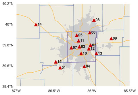
Historical tower network for the INFLUX testbed. Some sites have since been decommissioned, and new ones established (see INFLUX for details). Tower locations are red triangles, the census-designated Indianapolis urban area is shaded in gray, and highways are indicated by orange lines. County boundaries are in blue, with the exception of Marion County in thicker purple.
Observation Network
Various types of atmospheric GHG observations have been deployed as part of the INFLUX project:
- Tower-based in-situ, continuous measurements of CO2, CH4, and CO
- Flask sampling of 14CO2 and other trace gases (currently at two towers)
- Periodic aircraft sampling of greenhouse gases and meteorological conditions
- Eddy covariance and radiative flux measurements for the purpose of model evaluation
- Scanning Doppler lidar used to determine 3-D wind fields and boundary layer depth
The tower network is shown in the figure below, and more details as well as links to the various data sets are found at the main INFLUX project page (influx.psu.edu).