Official websites use .gov
A .gov website belongs to an official government organization in the United States.
Secure .gov websites use HTTPS
A lock (
) or https:// means you’ve safely connected to the .gov website. Share sensitive information only on official, secure websites.
Summary
The Los Angeles (LA) Megacity Carbon Project was established in 2013 as the second NIST urban test bed. The goal of this project is to use atmospheric measurements of greenhouse gases (generally carbon dioxide and methane) to estimate emissions variability and trends in California’s South Coast Air Basin. The NIST testbed operates in collaboration with other GHG efforts in this region, including research and measurements funded and/or operated by NASA (e.g., CLARS) and NOAA (whole air sampling systems; periodic aircraft campaigns, etc.). The primary institutions working with NIST in this testbed are the Scripps Institution of Oceanography and NASA’s Jet Propulsion Laboratory, along with our private partner, Earth Networks, Inc.
Description
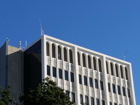
Air inlets and weather stations at the four corners of the roof of Caltech hall on the Caltech campus in Pasadena, Calif.
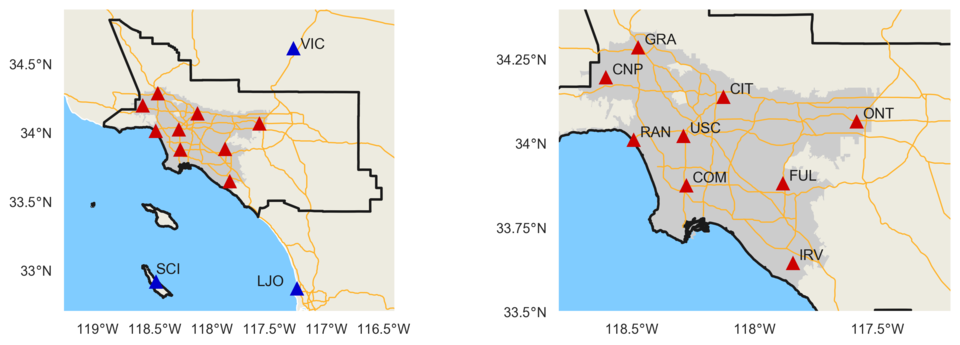
Observation Network
Tower and rooftop-based in-situ measurements of carbon dioxide (CO2) and methane (CH4) are the backbone of the LA Megacity test bed. This surface-based component of the LA observing system includes a network of Greenhouse Gas (GHG) monitoring stations that is intended to encompass the portions of the South Coast Air Basin producing the most intense GHG emissions (the urbanized portions of Los Angeles, Orange, Riverside, and San Bernardino counties). Measurements began a few years ago at several sites within the basin such as Caltech; sustained measurements have also been underway for many years from the Scripps Pier in La Jolla. Between 2013 and 2015 we completed installation of a 14-node measurement network within and around the LA basin. Most network sites are operated by Earth Networks, Inc., in collaboration with Scripps Institution of Oceanography, JPL, and NIST.
Every site is equipped with at least one in situ gas analyzer providing high-accuracy, continuous measurements of carbon dioxide (CO2) and methane (CH4) mole fractions, and about half of the sites measure carbon monoxide (CO). Two of the sites were deployed in the high desert and on an island to help track the relatively clean “background” air conditions and to track the outflow of polluted air from the basin. High-precision trace gas analyzers sample the air using pumps and air hose inlets located on towers or tall buildings. Every site is also equipped with one or more weather stations to help interpret the greenhouse gas measurements.
As with the other two testbeds, tower-based continuous observations of CO2, CH4, and CO are calibrated to WMO scales and reported with time-varying uncertainties, calculated in the manner documented in Verhulst et al. (2017) and Karion et al. (2020). Measurement data is publicly available and accessible at https://doi.org/10.18434/mds2-2388.