
Official websites use .gov
A .gov website belongs to an official government organization in the United States.
Secure .gov websites use HTTPS
A lock (
) or https:// means you’ve safely connected to the .gov website. Share sensitive information only on official, secure websites.
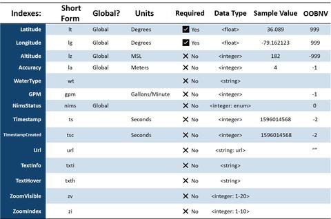
Hydrant / Water Souce Schema
Hydrant / Water Source Schema (object name: h2o)
Describes the attributes of hydrant and water source locations
NOTES:
This schema utilizes the following naming convention for the beginning character(s) of the Short Index name:
- 'l' fields related to a GPS location – uses Global elements from the GPS object
Within the schema, certain indexes may require additional clarification. The following list gives additional information for these elements:
- WaterType: the type of water source. If there is no value in the field, the default is “hydrant”. Other types of water sources could be “pond”, “draft”, “dry”, and “tank”. (A finite list of options here would be preferable and would allow for the possibility of using an enumerated value (a number in place of text) for the most common types).
- NimsStatus: an enumerated list of values outlining the key NIMS status categories that are relevant in the field. If there is no value within the field the status is assumed to be 'Available'. The concept of the NIMS Status is described in the “Additional Perspective” box below.
- Timestamp: used for cache control of the map annotation object
- TimestampCreated: for RMS use and would typically not be passed on to IoT devices.
- Url: a web URL linking to additional information pertaining to the icon
- TextInfo: a string describing the map annotation icon
- TextHover: a web concept that provides text information when a mouse is hovering over an icon. If there is no value in the TextHover field, then the value within the TextInfo field is used as hover text.
- ZoomVisible, ZoomIndex: concepts taken from several different map tile (raster scan) based systems. Both are valuable in controlling visibility at various levels of magnification, such as when several map icons are on top of each other at a specific zoom level but space appropriately when the zoom index is increased (the map is zoomed in further).
Note that all these defaults and enumerated value lists specified here will greatly reduce the size of the final encoded data object.
Additional Perspective
While map icons could be used for the hydrant and water source elements, it is not uncommon to have thousands of hydrant locations, and this could quickly overwhelm a map view.
Another obstacle for fire service iconology is the incorporation of NFPA standards. One possibility is to have a unique URL of "nfpa" that would indicate that the icon for the hydrant should be a color-coded hydrant based on the GPM/Available Flow. This would also save having to retrieve a URL from the network when in a reduced connectivity environment. Alternately, a null URL could indicate that a generic hydrant symbol should be used.
The NimsStatus field described above would allow departments to easily represent the most used NIMS statuses. The difficulty here is that these elements must be agreed upon. Many systems expand on the basic NIMS concepts of status which are "Available”, “Assigned” and “Out-of-Service." These statuses can be used for facilities (e.g., hydrants or hospitals), apparatus, and responders. An example starting point for an expanded nimsStatus list is shown below:
0 Unknown Out of band null value (OOBNV), for when data cannot be obtained
1 Out of Service Resource cannot be attached to calls, often associated with mechanical issues or reasons that will "take time" to fix
2 Available Resource can be attached to calls
3 En Route Resource is on the way to the scene
4 On Scene Resource is on scene at the incident location
5 Off Scene Resource still attached to the call, but not at the incident location. Could be going to a hospital, could be going to get water
6 Unavailable Resource not out of service, but having equipment cleaned or put back on after a call. Sometimes called the "In Quarters" status.
7 Deploying Resource driving a long distance to get to a staging area. Often used for disaster assistance or coverage to a mutual aid coverage area. The resource is in transit and not available to be assigned to a call.
Note that water sources, like most fixed location resources, can be either “Available” or “Out of Service”.