
Official websites use .gov
A .gov website belongs to an official government organization in the United States.
Secure .gov websites use HTTPS
A lock (
) or https:// means you’ve safely connected to the .gov website. Share sensitive information only on official, secure websites.
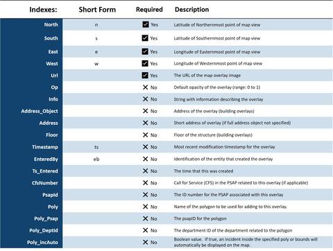
Map Overlay Schema
Map Overlay Schema (object name: mapOverlay)
Details pertaining to images that can be superimposed on a map.
NOTES:
In the Geographic Information Systems (GIS) environment, there is the concept of a "shape file" which is a collection of polygons or poly lines. A map overlay is an image file (e.g., .png, jpg) that is placed on top of a map. Typically, the shape file has a lot of transparent pixels. It also has opacity, a common feature of most map display systems, and it has metadata.
An example of an overlay is one that was created for the trail system in a state park. The original GIS supplied data was about 1 MB. The overlay that was created out of that was 16 KB, a compression of over a factor of 60 times. The concept of an overlay exists in HTML5, Google Maps and Open Layers.
This information is presented in a format different to the previous data objects because it is not a typical IoT schema. It is presented here as an example of a schema for a server-side data resource.