Official websites use .gov
A .gov website belongs to an official government organization in the United States.
Secure .gov websites use HTTPS
A lock (
) or https:// means you’ve safely connected to the .gov website. Share sensitive information only on official, secure websites.
Taking Measure
Just a Standard Blog
It is February 1994 and I am on the research vessel R/V Moana Wave off the coast of Lanai, Hawaii, with the team of the Marine Optical BuoY (MOBY) project. The water is incredibly blue, and I can’t help but be awestruck by the enormous energy, momentum, power and depth of the ocean as I watch the currents and the wind create what appear to be rising and falling pyramids of solid substance, no longer a liquid but a mighty living thing. It is against this backdrop that we work to deploy devices designed to determine the optical properties of the Pacific Ocean. As the instrument at hand, bright yellow and wing-shaped, is lowered over the port side into the water, its yellow wings appear green. This change, and indeed the blue color of the water itself, was indicative of what was in the water, which in the case of the open Pacific, was “not much.” “Much” meaning small particles in the water that scatter or absorb sunlight, changing the overall reflectance of the sunlit layer, and thereby the observed color.

One class of these small particles is phytoplankton, a form of algae. They contain chlorophyll and practice photosynthesis as does any other plant, using solar radiation to convert carbon dioxide dissolved in the water into plant sugars, releasing oxygen and respiring a portion of the carbon dioxide. A portion of the carbon dioxide is eventually converted to sediment thanks to the grazing activities of marine life (and death), such as zooplankton, young fish or crustaceans and those that feed upon them.
Phytoplankton are the basis of marine life, produce about half of the oxygen in the Earth’s atmosphere, and currently absorb much of the carbon dioxide we humans produce. Ocean temperature, currents, acidification, surface winds and nutrients can affect phytoplankton populations, life cycles and the amount of carbon dioxide they remove from the atmosphere, and so measuring them is critical to understanding climate change. A reasonable question to ask is “Will the oceans continue to remove significant amounts of human-produced carbon dioxide in the future?”
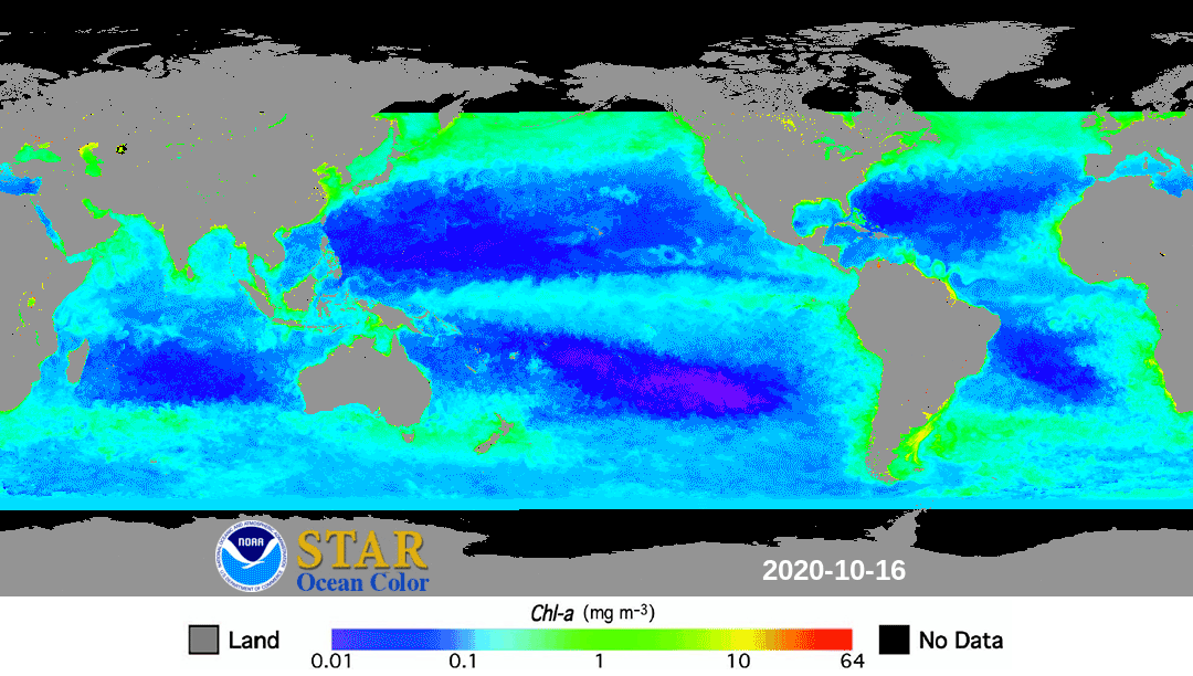
We need to continually observe the color of the world’s oceans to address these questions, and ocean color satellites have been in continuous operation since the launch of NASA’s SeaWiFS mission in 1997. The idea is simple: Just as you can tell a desert from a forest by the color, so it goes with the oceans. But, while the idea is simple, detecting the color of the oceans through Earth’s atmosphere is not. The main problem is the atmosphere also scatters sunlight, and both sources of scattered light, from the ocean and the atmosphere, are detected by the satellite sensor. Because the portion from the atmosphere dominates, it is not possible, with the current status of preflight calibration and atmospheric modeling, to use ocean color satellites to derive the light scattered out of the oceans with the accuracy we need to determine the chlorophyll concentration and other quantities of interest.
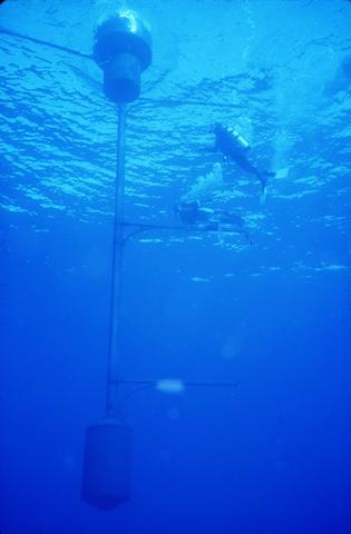
The solution lies in a procedure called system vicarious calibration (SVC), which was pioneered by Dennis Clark at NOAA and colleagues from ships during the Coastal Zone Color Scanner satellite mission (1978 to 1986). Based on this experience, Dennis implemented the MOBY project with support from NOAA and NASA’s SeaWiFS and MODIS projects; MOBY has produced data from July 1997 to the present. MOBY is an optical system that measures light at different colors (wavelengths). This type of system is called a spectrograph. It is mounted on a tethered wave-rider buoy and measures the light incident on the surface and at three depths, and the backscattered light at four depths. MOBY is located about 20 kilometers from Lanai where the water is representative of the world’s oceans. Data are acquired daily as ocean color satellites fly over the location. The MOBY instrument, in collaboration with NIST, is extremely well characterized and extensively calibrated, and the results are traceable to the International System of Units (SI), the modern metric system. By providing accurate values for the oceanic portion of the light measured by the satellite sensor, MOBY provides a calibrated source for any ocean color sensor that observes this region of the ocean.
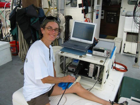
I was on the Wave in 1994 because Dennis had come to NIST a couple of years earlier for help with establishing traceability to the SI, which means ensuring the MOBY results are rigorously connected to the SI measurement system so that researchers around the world have the best possible ocean color reference. He had designed a robust measurement plan, with cross-checks and validation at every turn. Over the years, NIST has supplied radiometric sensors for the MOBY team to track its calibration sources in between the NIST calibrations, and we have deployed additional NIST radiometers and sources on occasion to validate the radiometric scales at the MOBY facility in Honolulu.
NIST has also played a role in characterizing the MOBY optical system. A good example is a problem Dennis presented early on: Independent, simultaneous measurements at the same wavelength and depth did not agree. Now, this is a problem, but really it is a good thing to find issues. In metrology, in order to assure ourselves we are getting the best (and hopefully correct) answer, it is good practice to measure the same thing with different approaches, in this case the backscattered light at the same wavelength with two different spectrographs. It took a while to figure out, but thanks to some laser characterizations and subsequent discussions, we identified stray light as the issue and developed and implemented an algorithm to correct the problem.
As you may have gathered, MOBY has been around for quite some time. It is an example of how collaborations really work, leading to a world-class product. We’re currently on our 67th buoy (a buoy has a deployment cycle of three to six months). We rotate two systems, calibrating and refurbishing one while the other is in the water. NOAA fully supports the MOBY project for its visible infrared imaging radiometer suite (VIIRS) calibration. Presently, under the leadership of Kenneth Voss (University of Miami; Dennis retired in 2005 and died in 2014) and execution of Moss Landing Marine Laboratories, and with NOAA support, we are implementing a new system design. The new optical system collects data from all depths simultaneously in order to reduce environmental sources of measurement uncertainty. A new carbon-fiber buoy structure, and new control, communication, and data analysis systems complete the system, which we call “Refresh.”
The MOBY team, with NASA funding, is developing a portable version termed MarONet. This system is identical to Refresh and enables deployment at a new location with recalibrations in Honolulu at the MOBY facility. The first MarONet will be deployed off Rottnest Island, Australia, in 2022. NIST’s role in MarONet is to supply a stable source and spectroradiometer system to validate any changes with shipment. In 2022, NASA will decide whether to continue the MarONet project as the primary SCV site for the upcoming Plankton, Aerosol, Cloud and ocean Ecosystem (PACE) mission.
I would like to close with a few words about the MOBY team and how this work has been a core part of my career at NIST. Yes, I have been involved with other satellite sensors, performing on-site validation activities at the manufacturer facilities with my NIST colleagues for the NASA Earth Observing System program, NOAA geostationary satellites, ESA’s Sentinel-2, the Orbiting Carbon Observatory and others. I have had the opportunity to participate in validation of ground-based measurements of the Moon’s irradiance. But the field of ocean color has led to long-standing relationships with exceptional scientists, and I am so grateful for this experience.