
Official websites use .gov
A .gov website belongs to an official government organization in the United States.
Secure .gov websites use HTTPS
A lock (
) or https:// means you’ve safely connected to the .gov website. Share sensitive information only on official, secure websites.
WUI Definitions
Traditional WUI Definitions
The common conceptual definition of wildland-urban interface (WUI) is the geographical area where human development, including structures and other infrastructure, meets or intermixes with undeveloped wildlands.
The WUI is often further distinguished into two WUI types based on housing densities:
- Interface: High-density development adjacent to undeveloped wildland vegetation.
- Intermix: Lower-density housing mingled with undeveloped wildland vegetation.
While these definitions can be useful to identify general areas, they do not focus on the parcel-level details that characterize parcel-to-parcel and structure-to-structure fire spread that is characteristic of many WUI fire disasters.
|
Category |
Definition Component |
Federal Register |
Common Implementation |
CAL FIRE |
|---|---|---|---|---|
|
Interface |
Conceptual |
There is a clear line of demarcation between residential, business, and public structures and wildland fuels; wildland fuels do not generally continue into the developed area |
Developed land not dominated (i.e., < 50 %) by vegetation |
High-density development adjacent to undeveloped wildland vegetation |
|
Housing density |
≥ 3 structure/ac (741 structure/km2) |
≥ 1 HU/40 ac (6.18 HU/km2) |
>1 HU/20 ac (12.4 HU/km2) in Moderate, High, or Very High FHSZ |
|
|
Population density |
≥ 250 people/mi2 (96 people/km2) |
|
|
|
|
Vegetation cover |
Structures directly abut wildland fuels |
< 50 % |
Not dominated by wildland vegetation |
|
|
Buffer from wildland |
Up to 1.5 mi (2.4 km) from community border |
< 1.5 mi (2.4 km) from land with > 75 % vegetative cover |
Wildfire susceptible vegetation up to 1.5 mi (2.4 km) from interface |
|
|
Infrastructure |
Fire protection of the structures from both an interior fire and an advancing wildland fire provided by the local fire department. |
|
|
|
|
Intermix |
Conceptual |
There is no clear line of demarcation; wildland fuels are continuous outside of and within the developed area |
Developed land dominated (i.e., > 50 %) by vegetation |
Lower-density housing mingled with undeveloped wildland vegetation |
|
Housing density |
≥ 1 structure/40 ac (6.18 structure/km2) |
≥ 1 HU/40 ac (6.18 HU/km2) |
1 HU/20 ac to 1 HU/5 ac or >1 HU/5 ac (50 HU/km2) when dominated by wildland vegetation, in Moderate, High, or Very High FHSZ |
|
|
Population density |
(28 to 250) people/mi2 [(11 to 96) people/km2] |
|
|
|
|
Vegetation cover |
Structures are scattered throughout a wildland area |
> 50 % |
Dominated by wildland vegetation |
|
|
Buffer from wildland |
|
|
Wildfire susceptible vegetation up to 1.5 mi from intermix |
|
|
Infrastructure |
Fire protection districts provide life and property protection and may also have wildland fire protection responsibilities |
|
|
|
|
Note: HU = housing units |
||||
WUI Definition by SSD and Parcel Size
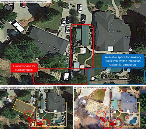
More specific WUI definitions are established in the HMM by explicitly adding the concept of structure separation distance (SSD). These definitions provide perspective and can help develop effective parcel-level mitigation strategies based on housing density and potential fire exposures.
WUI Type 1 and Type 2:
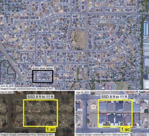
High-density interface communities with an SSD as small as 6 ft and parcel size of less than 0.5 ac. Type 1 is characterized by Perimeter and Type 2 as Interior WUI community. Significant portions of communities can get consumed in fire even with small number of ignitions in such settings.
WUI Type 3, Type 4, and Type 5:
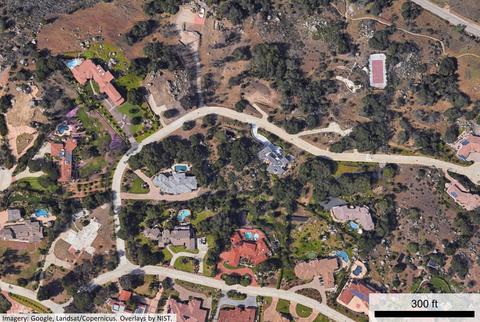
Medium-density construction with SSD ranging from 30 ft to 100 ft with parcel size in excess of 1 ac. Type 3 and Type 4 are characterized as interface and Type 5 as intermix communities.
WUI Type 6 and Type 7:
Low structure density at the interface (Type 6) and intermix (Type 7).
WUI Types classified by structure separation distance (SSD) and typical parcel size.
|
Type # |
WUI Type Name |
SSD (ft) |
Typical Parcel Size (ac) |
Typical Housing Density (struct/ac) |
|---|---|---|---|---|
|
1 |
High Density Interface – Perimeter |
6a to 30 |
< 0.5 |
2 to 8 + |
|
2 |
High Density Interface – Interior b |
6a to 30 |
< 0.5 |
2 to 8 + |
|
3 |
Medium Density Interface – Perimeter |
30 to 100 |
0.5 to 1+ |
< 2 |
|
4 |
Medium Density Interface – Interior b |
30 to 100 |
0.5 to 1+ |
< 2 |
|
5 |
Medium Density Intermix |
30 to 100 |
0.5 to 1+ |
< 2 |
|
6 |
Low Density Interface |
100+ |
1+ |
< 1 |
|
7 |
Low Density Intermix |
100+ |
1+ |
< 1 |
|
For SI: 1 ft = 0.305 m, 1 ac = 0.4 ha |
||||