
Official websites use .gov
A .gov website belongs to an official government organization in the United States.
Secure .gov websites use HTTPS
A lock (
) or https:// means you’ve safely connected to the .gov website. Share sensitive information only on official, secure websites.
How Scientists Measured the Washington Monument's Height
- In the 1930s, a NIST engineer revealed that the Washington Monument's poor weight distribution caused cracks and hollow spaces. He came up with a plan to redistribute some of that weight.
- Decades later, NIST experts took advantage of more repairs on the structure and traveled to the top to get more accurate measurements of the monument.
- Later, experts came up with a new measurement using more updated technology that's slightly shorter than the original known value.
How do you measure a structure as tall as the Washington Monument? Very carefully—using GPS.
Between 1998 and 2001, the Washington Monument was surrounded by scaffolding due to a restoration project. The scaffolding gave the National Oceanic and Atmospheric Administration (NOAA) the opportunity to temporarily place a GPS receiver atop the monument. NIST engineers designed, built and installed a special mounting that rigidly held the receiver in place and helped pinpoint the GPS signal.
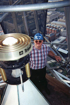
The resulting measurement was the most accurate one taken of the Washington Monument at the time. The measurement set the monument’s height at 169.26 meters (555 feet, 3-5/8 inches), only 3.8 centimeters (1.5 inches) off from the historically declared figure obtained with traditional surveying methods.
However, in 2015, experts from NOAA used new technology to measure the monument's height at 554 feet, 7 11/32 inches.
Did You Know...?
-

Looking down at the top of the Washington Monument, a spot visited twice by NIST engineers in the last century. Credit: National Park ServiceMeasuring the Washington Monument wasn't NIST's first time working with the structure. In 1934, building stone specialist Daniel W. Kessler revealed that a poor distribution of the monument's weight created hollow spaces and cracks. His solution was to redistribute the weight of the lower section by filling in the hollows with more elastic mortar than originally used.
- Construction on the Washington Monument began in 1848, and by 1854, it had reached a height of 48 meters (156 feet). Political disagreements and a lack of funds then stalled the project, leaving an unfinished landmark for the next 22 years. The structure was finally completed on Dec. 6, 1884, when an aluminum tip was placed atop the capstone—the same section that would be examined 50 years later by NIST engineers.