
Official websites use .gov
A .gov website belongs to an official government organization in the United States.
Secure .gov websites use HTTPS
A lock (
) or https:// means you’ve safely connected to the .gov website. Share sensitive information only on official, secure websites.
Summary
Ocean color radiometry provides essential information about phytoplankton concentration and dissolved organic matter, and hence about primary productivity, global carbon cycling, and ultimately the effects of both on planet Earth.
Description
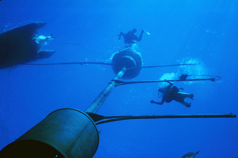
Seen from the base of the MOBY spar, researchers work on the the facility. MOBY is deployed in clear waters about 1200 meters deep, far enough from shore to be visible to satellites.
The primary reference instrument for the United States and most international ocean-color sensors is the Marine Optical Buoy (MOBY), an automated radiometric system operated by NOAA and deployed about 20 km offshore from Lanai, Hawaii, where the atmospheric and water conditions support utilizing this area as a surface radiometric reference standard. The water is representative of most of the world’s oceans -- clear, has low chlorophyll and good spatial uniformity; likewise, the atmosphere is clear (low aerosols) so atmospheric correction is more certain. Clouds can prevent satellite observations of the MOBY site, but the system is optimally located for local conditions.
MOBY uses optical fiber-coupled collectors mounted on three long arms that stand off its central axial mast to detect both downwelling irradiance and upwelling radiance at depths of 1 m, 5 m, and 9 m, and at wavelengths from 340 nm to 950 nm. The optical fibers mate to two spectrographs (for long and short optical wavelengths) in a 2 meter-long canister at the base of the axial mast. The system also records downwelling spectral irradiance just above the sea surface, and upwelling radiance from directly beneath the axis.
MOBY has been in operation since 1997. It is operated for NOAA by principal investigator Ken Voss of the University of Miami (UM), with co-investigators Art Gleason (UM) and Mark Yarbrough of Moss Landing Marine Laboratory (part of the California State Universities). The instrument's data are used to determine on-orbit calibration factors for various satellite sensors including the long-running MODIS on NASA’s Terra and Aqua satellites, and the Visible Infrared Imaging Radiometer Suite (VIIRS) aboard NASA's Suomi National Polar-orbiting Partnership (Suomi NPP) spacecraft and the NOAA-20 weather spacecraft. The MOBY team has implemented MOBY-Refresh for NOAA that replaced the aging MOBY. The first deployment was coincident with MOBY utilizing a second mooring installation. In May of 2024, the first Refresh in the series was deployed. In a complimentary effort, the MOBY team implemented a second system vicarious calibration (SVC) site in the Indian Ocean, just west of Perth, Australia, termed MarONet. Funded by NASA, the MarONet deployment series began in September 2024 and the data are being used for NASA’s Plankton, Aerosol, Cloud, ocean Ecosystem (PACE) mission that launched in February 2023. The co-investigator for MarONet is David Antoine of Curtin University.