
Official websites use .gov
A .gov website belongs to an official government organization in the United States.
Secure .gov websites use HTTPS
A lock (
) or https:// means you’ve safely connected to the .gov website. Share sensitive information only on official, secure websites.
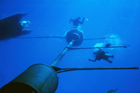
Seen from the base of the MOBY spar, researchers work on the the facility. MOBY is deployed in clear waters about 1200 meters deep, far enough from shore to be visible to satellites.
Much of what is known about the state of the Earth's oceans, and how they change over time, comes from satellite monitoring of reflected and thermally emitted light from these bodies. Thermally emitted radiation occurs in the infrared spectral region and is the basis for studies of sea surface temperature.
In the visible spectral region, the amount of sunlight absorbed or scattered by seawater varies substantially depending upon the amount and type of dissolved and suspended materials, which determine the optical properties of seawater. As the constituents vary, the color of the ocean changes.
In particular, ocean color radiometry provides essential information about phytoplankton concentration and dissolved organic matter, and hence about primary productivity, global carbon cycling, and ultimately the effects of both on the planet's climate.
Understanding the dynamics of these variables involves analyzing datasets from multiple satellite sensors over decadal time scales. But in order to draw meaningful conclusions from the data, scientists need to know the sources of uncertainty in measurements. That is a remarkably complex and difficult problem – one that PML researchers have been addressing for years.
"From space, you're looking down through the atmosphere and trying to determine the upwelling light emerging from the sunlit region of the ocean, which can be as deep as 200 meters, depending on wavelength," says physicist B. Carol Johnson of the PML's Optical Radiation Group, "and the science requirements call for a total relative combined system uncertainty of 5 percent in this quantity, termed the 'water-leaving radiance.'
"But at the satellite sensor, 90 percent or more of the incoming radiation is from the atmosphere itself, or from sea-surface sun glint, or wave foam, or something else. At most, only about 10 percent of the incident light is the ocean color signal of interest. So if you want to have an uncertainty of 5 percent in a signal that is only 10 percent of the total radiance at the satellite, you would need on-board sensors accurate to 0.5 percent to get your target uncertainty.
"Since the 10 percent is an upper limit, the radiometric accuracy of the ocean color sensor needs to be 0.1 to 0.2 percent. This, however, is about an order of magnitude better than the absolute calibration uncertainties of today's ocean-color sensors using traditional laboratory radiance standards."
One way around this obstacle is ground-truth validation, known as "vicarious calibration," using data from a suite of optical sensors placed in the ocean to measure the water-leaving radiance locally. Those in situ measurements are compared to what the satellite records when it is looking at the same part of the ocean at the same time. Vicarious calibration is an end-to-end calibration of the sensor and its data.
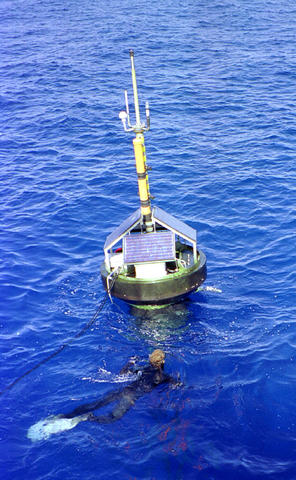
The primary reference instrument for the United States and most international ocean-color sensors is the Marine Optical Buoy (MOBY), an automated radiometric system operated by NOAA and deployed about 20 km offshore from Lanai, Hawaii, where the atmospheric and water conditions support utilizing this area as a ground radiometric reference standard. The water is clear (low chlorophyll) and the spatial uniformity is good and representative of most of the world's oceans; likewise the atmosphere is clear (low aerosols) so atmospheric correction is more certain. Clouds can prevent satellite observations of the MOBY site, but the system is optimally located for local conditions and the retrieval rate from cloud contamination is similar to typical cloud coverage fraction in ocean scenes.
MOBY uses optical fiber-coupled collectors mounted on three long arms that stand off its central axial mast to detect both downwelling irradiance and upwelling radiance at depths of 1 m, 5 m, and 9 m, and at wavelengths from 340 nm to 950 nm. The optical fibers mate to two spectrographs (for long and short optical wavelengths) in a 2 meter-long canister at the base of the axial mast. The system also records total irradiance just above the sea surface, and upwelling radiance from directly beneath the axis.
MOBY has been in operation since 1997, and is now operated for NOAA by principal investigators Ken Voss of the University of Miami, and Mark Yarbrough of Moss Landing Marine Laboratory (part of the California State Universities). The instrument's data are used to determine on-orbit calibration factors for various satellite sensors including the long-running MODIS and recent SeaWIFS instruments. NASA's Earth Observing System (EOS) supported the development of MOBY under the direction of Dennis Clark (NOAA, retired). Currently, teams of researchers are using MOBY to vicariously calibrate the Visible Infrared Imaging Radiometer Suite (VIIRS) aboard NASA's recently launched Suomi National Polar-orbiting Partnership (Suomi NPP) spacecraft.
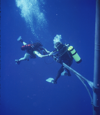
Of course, the instruments and data-collection system on MOBY itself have to be thoroughly characterized and calibrated – a complicated job for many reasons. To ensure robust SI traceability, a number of radiometric cross checks were implemented by Clark, and the data, which are acquired daily, are subjected to quality control analysis prior to release. Duplicate systems are rotated, in three month long deployment cycles at the Lanai site, in order to refurbish and repair the optical buoy.
For each deployment, a pre- and post-radiometric and wavelength calibration is performed using radiometric standards calibrated by NIST. In addition to the deployments, monthly visits to MOBY are required to allow divers to clean the optics and record the instrument response to stable diver-held calibration sources. Internal to MOBY, two LEDs and one lamp serve as on-board stability monitors for the internal optical system. The radiometric reference standards are recalibrated every 50 hours of lamp burn time, and they are tracked during operating using two NIST-designed and calibrated filter radiometers. As a final check, NIST makes independent measurements of the radiance standards at the MOBY facility on Oahu using independent radiometric artifacts.
Since the project began, the PML team has participated in a number of characterization experiments for the MOBY system, including the cosine response of its irradiance collectors, the sensitivity of the radiometric response to ambient temperature, and optical linearity. A substantial effort has been centered on the effect of stray light in the MOBY's optical system, in particular the diffraction grating that provides spectra to the detectors.
Along with colleagues at Moss Landing and elsewhere, Johnson, Yuqin Zong, and colleagues Steven Brown and Keith Lykke of the Laser Applications Group devised and published an algorithm that corrects for this "stray" light. The necessary characterization data utilizes tunable lasers over the entire spectral range of the MOBY spectrographs. As there are two buoys, each with eight optical channels, and the spectrographs are high resolution, this study involved a tremendous effort. Initial measurements were made at the MOBY calibration facility, and three times thereafter the optical systems of the buoys have come to NIST's Spectral Irradiance and Radiance responsivity Calibrations using Uniform Sources (SIRCUS) facility in Gaithersburg, MD for full characterization. The effect of stray light was most evident in the spectral overlap region between the two spectrographs, e.g. around 620 nm, but for ocean color science it was the impact on the ocean color bands in the blue that was most significant, with corrections of up to 8 percent.
PML, led by Brown, has also contributed to the ocean color field by way of recognizing the need for advanced radiometric sources, e.g. ones that could better match the blue-rich spectral distribution of the oceanic waters using solid state sources such as LEDs.
MOBY is beyond its design life, and PML has been active in the best optical system design for the replacement sensors. Brown realized the advantage of acquiring data from all channels (e.g. depths) simultaneously by coupling the optical fibers directly to the spectrograph entrance slits. Two prototypes were built and tested, followed by an instrument that uses a prism-grating-prism design.
Johnson and co-workers are midway through a NASA-funded project to examine the entire time series of MOBY data set and provide a comprehensive uncertainty analysis including identifying sources of bias, developing correction algorithms for those biases, and assessing and assigning uncertainties. The result will not only improve the accuracy of the MOBY data set, but also enhance the value of ocean-color science products to climate research and other fields.
An identified source of bias is instrument self-shading – the in-water shadowing caused by the sensors and their mountings. To measure upwelling radiance, the sensor is oriented towards nadir, so it looks through its shadow for this measurement. The significance of self-shading is highly dependent on the optical properties of the water, wavelength, position of the sun, orientation of the buoy's arms with respect to the sun, atmospheric conditions, and sea state.
A preliminary model of self-shading has been formulated for the MOBY system that involves Monte Carlo and in-water radiative transfer computations developed for the MOBY system by Jim Mueller of San Diego State University. The correction cannot be applied a priori because the optical properties (chlorophyll) are not known – they are what MOBY is meant to determine. Thus an approach had to be developed.
As part of the NASA uncertainty analysis project, a simple experiment was designed in order to validate the self-shading models and approach. The team took data in September of 2012 using the new instrument, Field Instrument for Shadowing (FISH). Team members included researchers from NIST, MLML, NOAA, Utah State University's Space Dynamics Laboratory. Johnson and Mark Yarbrough of MLML were responsible for the integration of FISH.
FISH, which covers the 370 nm to 915 nm spectral region, was configured with seven of its 14 possible channels; one was configured to measure downwelling surface irradiance and the other six were configured to measure upwelling radiance. Two of the channels were "bare fiber," at two different depths. The other four radiance foreoptics were a set of occulting discs of different sizes that floated on the water's surface. These six channels were held off the stern of a small commercial vessel. The optical fiber bundle was 50 meters long, so the equipment could be positioned away from the boat.
The self-shading work involved several challenges, Johnson says. "For one thing, the ideal time to perform the experiment is when the solar zenith angle ranges from directly overhead to about 30 degrees during the approximately 10 a.m. to 3:00 p.m. observation times each day. At Hawaiian latitudes, the best times are from May to July. Thus, the September deployment missed the critical overhead times – where the shadow overlaps a nadir instrument to the largest extent, because we did not have the instrument ready. In addition, the sea state and cloud conditions are major, but unpredictable, factors. In all, however, the equipment operated very well, and we learned lessons for future efforts. The project was successful because of the professional, experienced, expert MLML team of oceanographers."
Eric Shirley, leader of the Optical Radiation Group, says that "MOBY is, and should continue to be, a unique and essential calibration utility for the top-tier environmental satellites (Terra and Aqua MODIS), Suomi NPP, and future satellites to be launched under the auspices of the Joint Polar Satellite Service."