
Official websites use .gov
A .gov website belongs to an official government organization in the United States.
Secure .gov websites use HTTPS
A lock (
) or https:// means you’ve safely connected to the .gov website. Share sensitive information only on official, secure websites.
Fire Progression Timeline
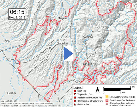
The Camp Fire ignited on November 8, 2018 in the foothills of the Sierra Nevada in Butte County, California. The first 24 hours were characterized by a fast-moving fire with initial spread driven by high winds up to 22 m/s (50 mi/h) and long-range spotting up to 6.3 km (3.9 mi) into the community. The fire quickly impacted the communities of Concow, Paradise, and Magalia. The Camp Fire became the most destructive and deadly fire in California history, with over 18 000 destroyed structures, 700 damaged structures, and 85 fatalities.
After a preliminary reconnaissance, it was determined that abundant data was available to support an in-depth case study of this devastating wildland-urban interface (WUI) fire to increase our understanding of WUI fire spread, fire behavior, evacuation, and structure response. The methodology guiding the case study and a detailed timeline reconstruction of the fire progression and fire behavior are presented. Over 2200 observations about fire spread and behavior were collected during the case study. Subsequent reports will detail additional aspects of the incident including emergency response and evacuation, and defensive actions and structure response.
This study has identified that Butte County and the Town of Paradise were well prepared to respond to a WUI fire, that the Camp Fire grew and spread rapidly and that multiple factors contributed to the rapid growth and spread of the Camp Fire. Additionally, this study identified the importance of the wildland fire ignition location relative to the community, that multiple parcel-level fire spread pathways caused structure ignitions, and that WUI fire spread impacted the affected communities in multiple ways beyond the destruction of residential and commercial properties.
Camp Fire Timeline Report
The full report, NIST Technical Note 2135, including large-format maps, may be downloaded from https://doi.org/10.6028/NIST.TN.2135 (PDF, 74 MB).
The report text and maps may be viewed/downloaded individually via the following links:
- NIST TN 2135 Report (PDF, 36 MB)
- NIST TN 2135 Maps (ZIP, 365 MB)
Map 1. Camp Fire Points of Interest and Frequently Referenced Roads and Locations (PDF, 27 MB)
Map 2. Fire Observations 06:25 to 07:45, November 8 (PDF, 25 MB)
Map 3. Fire Observations 07:45 to 08:30, November 8 (PDF, 25 MB)
Map 4. Fire Observations 08:30 to 09:00, November 8 (PDF, 26 MB)
Map 5. Fire Observations 09:00 to 10:00, November 8 (PDF, 26 MB)
Map 6. Fire Observations 10:00 to 11:00, November 8 (PDF, 26 MB)
Map 7. Fire Observations 11:00 to 12:00, November 8 (PDF, 26 MB)
Map 8. Fire Observations 12:00 to 13:00, November 8 (PDF, 26 MB)
Map 9. Fire Observations 13:00 to 14:00, November 8 (PDF, 26 MB)
Map 10. Fire Observations 14:00 to 16:00, November 8 (PDF, 31 MB)
Map 11. Fire Observations 16:00 to 19:00, November 8 (PDF, 31 MB)
Map 12. Fire Observations 19:00 to 23:00, November 8 (PDF, 31 MB)
Map 13. Fire Observations 23:00, November 8 to 02:00, November 9 (PDF, 31 MB)
Map 14. Fire Observations 02:00 to 09:00, November 9 (PDF, 31 MB)
NIST CAMP FIRE TIMELINE TECHNICAL PUBLICATIONS
- Maranghides A., et al. (2021) A Case Study of the Camp Fire – Fire Progression Timeline. NIST Technical Note 2135. National Institute of Standards and Technology, Gaithersburg, MD. https://doi.org/10.6028/NIST.TN.2135