
Official websites use .gov
A .gov website belongs to an official government organization in the United States.
Secure .gov websites use HTTPS
A lock (
) or https:// means you’ve safely connected to the .gov website. Share sensitive information only on official, secure websites.
Northeast Corridor Project Overview and Goals
The Northeast Corridor (NEC) was established in 2015 as the third NIST urban testbed, after Indianapolis and Los Angeles. The goals for this project are:
- To demonstrate that top-down atmospheric emissions estimation methods can be used in a domain that is complicated by many upwind and nearby emissions sources, specifically, surrounding urban areas. The objective is to isolate the anthropogenic GHG emissions from urban areas along the U.S. East Coast from many confounding sources upwind (cities, oil and gas development, coal mines, and powerplants).
- To use both ground-based and atmospheric measurements to understand the large biological CO2 signal from the highly productive agricultural areas and forests nearby and within the cities. The presence of highly vegetated areas such as urban parks, local agriculture, and managed lawns is expected to dominate the CO2 signal in summertime.
- To demonstrate the use of multiple inverse model constructions using both tower-based and aircraft-based observations to infer emissions of anthropogenic CO2 and CH4 from urban regions in the Northeast US.
The NEC project has a current focus on the urban areas of Washington, D.C. and Baltimore, Maryland, U.S.A., with existing plans to expand northward to cover the entire urbanized corridor of the Northeast U.S., including the cities of Philadelphia and New York City, and eventually linking up with existing measurement stations in Boston, Massachusetts (McKain et al., 2015; Sargent et al., 2018).
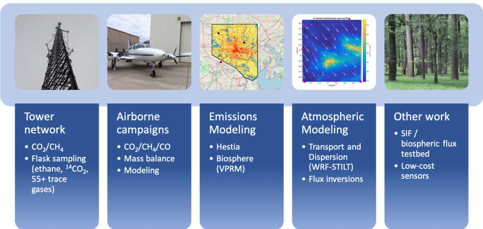
The NEC project includes multiple measurement and analysis components (Fig. 1). The backbone of the NEC project is a network of in-situ CO2 and CH4 observation stations with continuous high-accuracy mole fraction measurements of these two greenhouse gases. In addition, periodic flight campaigns of multiple weeks each year are conducted by the University of Maryland (FLAGG-MD), and Purdue University, focusing on wintertime observations of CO2, CH4, CO, O3, SO2, NO2, from instrumented aircraft (Ren et al., 2018; Salmon et al., 2018; Ahn et al., in prep.; Lopez Coto et al., in review). The use of low-cost CO2 sensors is also being investigated in Washington, D.C., with work focusing on calibration and determination of long-term stability of inexpensive non-dispersive infrared (NDIR) sensors (Martin et al., 2017).
The NEC project also includes an extensive modelling component. First, high-resolution meteorological modelling (using the Weather Research and Forecast (WRF) model) is being conducted, with output coupled to Lagrangian dispersion models such as STILT (Lin et al., 2003) and HYSPLIT (Stein et al., 2015). These transport and dispersion models are used to interpret observations from both aircraft and tower stations and will be used in atmospheric inverse analyses to estimate fluxes of CO2 and CH4 from the cities of Washington, D.C. and Baltimore, Maryland (Lopez Coto et al., in review; Ghosh et al., in prep.). We will also use an inverse model to estimate fluxes from a larger region surrounding and upwind of the Washington, D.C. area in order to understand the impact of upwind and nearby emissions sources and vegetative sinks on urban GHG concentrations. A high-resolution fossil-fuel CO2 inventory, Hestia, is also being developed for this project (Gurney et al., 2012; Gurney et al., 2019).