Official websites use .gov
A .gov website belongs to an official government organization in the United States.
Secure .gov websites use HTTPS
A lock (
) or https:// means you’ve safely connected to the .gov website. Share sensitive information only on official, secure websites.
Observational Network
NIST has partnered with Earth Networks, Inc. to deploy tower-based CO2 and CH4 measurements in the Northeastern United States.
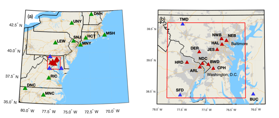
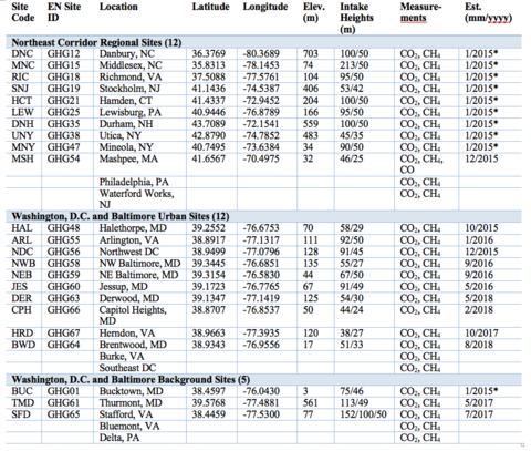
Initially we have focused on a dense network around the Washington, DC and Baltimore, MD region (Fig. 1), beginning in October 2015. We have established additional stations in neighboring states (Table 1), and we plan to establish two additional sites in the Philadelphia-New Jersey region in 2020.
Urban tower locations (red triangles, Fig. 1) were determined using a network design study (Lopez Coto et al., 2017), with locations intended to maximize coverage of anthropogenic carbon dioxide emissions associated with the two cities. Background tower locations (blue triangles, Fig. 1) were determined by a separate design study (Mueller et al., 2018), with sites chosen to best characterize the incoming air mass for the urban locations. Measurements at the urban network sites began in October 2015. Additional existing Earth Networks sites throughout the Northeast have also now been included in our project (green triangles), with one established specifically for the project (MSH, Mashpee, MA).
Tower-based continuous observations of CO2 and CH4 are calibrated to the WMO scales and reported with time-varying uncertainties, calculated in the manner documented in Verhulst et al. (2017) and Karion et al. (2020). Measurement data is publicly available and accessible at https://doi.org/10.18434/M32126.
Whole air samples are collected in flasks at a subset of tower locations (MSH, NEB, NWB, BWD, and TMD) for analysis by the National Oceanic and Atmospheric Administration’s Earth System Research Laboratory for hydrocarbon, halocarbon, and GHG species, as well as 13CO2 and radiocarbon.