
Official websites use .gov
A .gov website belongs to an official government organization in the United States.
Secure .gov websites use HTTPS
A lock (
) or https:// means you’ve safely connected to the .gov website. Share sensitive information only on official, secure websites.
Resilience Data Standardization: Spatial Support System for Community Assessments and Decision Making
Summary
This project aims to bridge a critical gap in post-disaster data collection by developing a standardized, interdisciplinary methodology for assessing damage, losses, and functional recovery that integrates social, spatial, and structural physical data. Currently, despite the unique opportunity post-event reconnaissance offers for gathering perishable real-world data that cannot be replicated in a lab setting, there's a significant lack of standardized tools and best practices for collecting and integrating multidisciplinary information across various temporal, spatial, and social scales. This includes the effective use of probability-based sampling strategies to ensure data representativeness, which has been identified as a key challenge by NIST and its partners.
This effort unifies the strengths of three major NIST programs: the Community Resilience Program (CRP), which develops planning guidance, resilience metrics, and systems models at the community scale; the Disaster Failure Studies Program (DFSP), which investigates building and infrastructure performance and deploys reconnaissance teams to collect critical perishable data; and select studies within the NIST Materials and Structural Systems Division (MSSD), specifically its Structural Systems and Earthquake Engineering expertise, which contributes deep technical knowledge in structural response and advances instrumentation and analysis of built environment performance.
The project proposes a modular post-disaster assessment methodology that leverages a Spatial Data Collection Support System (SDCSS). This SDCSS will integrate hazard characterization data, engineering-based damage assessments of buildings and infrastructure, and validated socio-economic survey and interview instruments. A crucial aspect is an underlying spatial structure to link all collected data, enabling standardized, scalable, and interdisciplinary data collection across spatial, social, and temporal scales. The system will also allow for the population of secondary pre-event data, such as demographics, housing, community asset locations, and infrastructure networks, to enhance situational awareness during reconnaissance missions. Furthermore, the project will explore the utility of AI and other virtual reconnaissance tools to enhance efficiency. This comprehensive approach will support comparative research, inform improvements in codes and standards, and provide actionable insights to help communities better understand and enhance their resilience to future hazards.
Description
Objective
To develop and validate a modular, GIS-based Spatial Data Collection Support System (SDCSS) for post-disaster reconnaissance, impact and recovery tracking that enables standardized, interdisciplinary data collection across social, spatial, and temporal dimensions. This system will integrate data collection instruments and virtual reconnaissance tools to systematically measure, monitor, and evaluate community resilience.
Technical Idea
Spatial Data Collection Support System (SDCSS) is a framework for integrating multi-disciplinary spatial data, analysis tools, and decision-making logic to support decision-making by communities. With challenges such as integrating multidisciplinary datasets and scales, SDCSS offers an approach to systematically collect, store, and analyze data collected in the field and by virtual reconnaissance and monitoring through internet sources. The SDCSS will support comparative analysis, inform codes and standards development, and provide actionable insights to strengthen community resilience through improved disaster response and recovery practices.
The ultimate goal is to develop a comprehensive suite of Coordinated & Collaborative Local Evidence Collection Tools (COLLECT) designed for adaptability and accessibility across diverse users and scales. This ambitious objective necessitates a multi-faceted approach, beginning with user-centric design principles that involve diverse stakeholders throughout iterative UX/UI development to ensure intuitive and practical tools. A scalable architecture is paramount, leveraging GIS and AI to handle data from individual site assessments to regional reconnaissance without performance degradation. The tools will feature modular and customizable interfaces to cater to varying user proficiencies, from simplified volunteer interfaces to advanced researcher functionalities. Interoperability and open standards will ensure seamless data exchange with existing platforms, while robust offline capabilities will address connectivity limitations during disasters. Finally, the initiative includes developing comprehensive training and support materials and integrating data sharing and collaboration platforms to foster a truly collaborative environment for reconnaissance and recovery efforts.
Research Plan
This research will use GIS-based and other tools to support multiscale (i.e., spatial and temporal) and multidisciplinary longitudinal data collection and synthesis through field and virtual reconnaissance to provide community assessment and information for decision support. In response to challenges in data collection for disaster reconnaissance, evaluation, and recovery—such as the difficulty of capturing data before, during, and after hazard events; integrating information across site-specific to regional scales; and accounting for complex interactions between social, built, and natural systems—this study investigates how SDCSS can be used to structure and operationalize comprehensive field data collection.
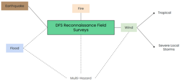
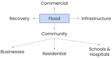
Each hazard type has different data needs. The data collection instrument has a modular design (Figure 1), which allows for standardization and ease of deployment. At the center of the modular surveys is the hazard characterization questions. This will be developed to have the same questions regardless of the hazard. Then, there are hazard-specific surveys. The modular design is so that there is a template set of questions for each hazard. DFSP primarily conducts reconnaissance for Earthquake, Wind (Tropical or Severe Local Storms), and Flood hazards. There is an option for a Multi-Hazard survey, which will combine hazard surveys. For example, a Hurricane reconnaissance survey would combine the Wind-Tropical survey with the Flood survey. A Fire survey will be developed further down the line. Each hazard module is expected to have the same category of questions to measure recovery and resilience (Figure 2).
This research incorporates participatory methods, such as workshops with subject matter experts to co-identify relevant indicators and inform tool design. Review of existing tools related to data collection and organization is critical, as well as a review of tools that ingest data for use in research, development, and modeling of community resilience, such as the Interdependent Networked Community Resilience Modeling Environment (IN-CORE). The SDCSS platform will allow for integrating diverse datasets, supporting temporal analyses, and visualizing patterns of vulnerability and recovery across geographies. By exploring both the technical design and practical application of GIS and AI in multidisciplinary reconnaissance efforts and maintaining an effort on validation and verification, this project contributes to advancing reconnaissance and community resilience standards.
Major Accomplishments
A basic literature review in the form of a NIST Research Brief will be published in FY25, which provides the schematic for the structure of the SDCSS.