

Official websites use .gov
A .gov website belongs to an official government organization in the United States.

Secure .gov websites use HTTPS
A lock (
) or https:// means you’ve safely connected to the .gov website. Share sensitive information only on official, secure websites.


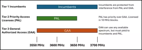
Wireless devices, from your phone to the internet router at work, need access to slices of radio frequencies to carry signals through the air. These slices are known as spectrum. Spectrum is a finite resource, and as technology advances, demand for it continues to grow, straining the supply of open frequencies. Dynamic spectrum sharing is one answer to this problem and involves allowing different users to share the same frequencies rather than giving each user an exclusive slice.
The Citizens Broadband Radio Service (CBRS) band is a test of that idea. Federal Communications Commission (FCC) rules allow commercial networks to use the CBRS band (3550-3700 MHz), and share the airwaves with federal incumbents, who hold priority and have operated in the allocated band for decades. Automated Spectrum Access Systems (SAS) assign channels and power levels to commercial devices, while a separate sensor network, the Environmental Sensing Capability (ESC), watches for federal activity. When the ESC detects protected federal activity, the information is sent to the SAS, which directs affected CBSDs to cease operation on, or move from, frequencies necessary to protect the incumbent.
A key protection concern is not simply the emission from an individual commercial device, but the aggregate contribution from many devices operating simultaneously. Dynamic spectrum sharing depends on accurately predicting and validating the aggregate emissions from these Citizens Broadband Radio Service Devices (CBSDs), based on assumptions about how signals travel, how buildings and terrain block them, how often devices actually transmit, and how densely they are deployed. These assumptions require validation against real-world measurements. Without real-world validated aggregate emission models, incumbent systems may not receive adequate protection, or the spectrum may be underutilized. Reliable modeling benefits both federal and commercial spectrum users by enabling efficient sharing and building towards coexistence.
The CBRS Sharing Ecosystem Assessment (SEA) program which is enabled by technical partnership between NIST’s Communications Technology Laboratory (CTL), NTIA’s Institute for Telecommunication Sciences, NASA Langley Research Center, and the MITRE Corporation addresses this challenge by collecting reliable measurements and comparing them with models. This program runs through the National Advanced Spectrum and Communications Test Network (NASCTN), hosted within CTL and sponsored by the Defense Information Systems Agency (DISA). Operating as an independent, trusted agent, NASCTN provides impartial, scientifically rigorous testing, measurement data, and validated modeling methodologies that both federal and commercial parties can rely on.
Modeling and Validation
Closing that gap between prediction and reality is the core of NASCTN’s work in this space. Industry provides records of registered commercial devices nationwide, including each device’s registered operating parameters, such as maximum transmit power, frequency, and channel width. From those records and assumptions about device activity, NASCTN’s model calculates how much energy each device would deliver to a given location, accounting for distance, terrain, clutter, and the receiving antenna, then sums the contributions from every device in the surrounding area, channel by channel. The calculations follow reference algorithms published by the Wireless Innovation Forum, the industry body whose specifications the operational CBRS ecosystem runs on. The resulting predictions can then be compared with field measurements to evaluate how well the models represent real-world conditions.
NASCTN teams deployed instruments near Norfolk, Virginia, and San Diego, California, as part of a longer-term monitoring network that also includes Camp Pendleton, to record the radio environment continuously. This sensor network has generated high quality data over 2 years, with 4767 sensor days available to the public. Researchers compared select recordings against the model’s predictions, sensor by sensor and channel by channel, giving the first direct measure of how well the reference models track in the real world. The program also produced an RF horizon mapping tool for its sensor sites and publicly released its repositories, technical manuals, and reports.
Modeling Improvements
NASCTN implemented both the original (CBRS 1.0) and revised reference algorithm (CBRS 2.0) versions so the two could be evaluated against the same measurements. The revised algorithm changes four things to the calculated aggregated emissions:
- Neighborhood distances: Reduces the radius within which nearby devices count as potential contributors, so fewer devices enter the calculation.
- Clutter modeling: Credits more signal loss from buildings, trees, and other obstructions, lowering the predicted total.
- Propagation assumptions: Updates the assumptions governing how signals weaken across distance and terrain.
- Interference calculation: Changes how individual device contributions are combined and compared against protection thresholds.
Collectively, these changes affect predicted aggregate interference and the modeled margin relative to incumbent protection criteria. NASCTN’s related investigation into neighborhood distances for Dynamic Protection Areas (DPAs), the geographic zones where commercial devices must yield when federal activity is detected, provides measurement-based evidence to inform how those distances are determined.
Looking Forward
NASCTN’s core contributions in aggregate emissions are a key driver to CTL's recently released Spectrum Science Roadmap which takes on this topic directly through two of the five roadmap goals:
- Develop a Harmonized Aggregate Emissions Definition: Scientifically grounded definitions of aggregate emissions and the measurement methods behind them, so commercial and federal estimates are rooted in shared terms.
- Define Standards for Spectrum and Environment Sensing: Essential features of spectrum data products, including measurement methods, data quality expectations, and grounded statistical analyses.
Both goals require continued collaboration with industry, academic, and government partners. Mid-band spectrum like CBRS is where much of the country’s wireless growth will have to come from. As an independent, trusted testing ground, CTL provides the impartial, scientifically rigorous testing and validated modeling that growth depends on. Measurement-based validation of spectrum-sharing models can provide federal agencies, industry, and standards organizations with a stronger technical basis for balancing incumbent protection with efficient commercial spectrum use.