
Official websites use .gov
A .gov website belongs to an official government organization in the United States.
Secure .gov websites use HTTPS
A lock (
) or https:// means you’ve safely connected to the .gov website. Share sensitive information only on official, secure websites.

The Joplin Tornado: A Calamity and a Boon to Resilience, 10 Years On
For many residents of Joplin, Missouri, May 22, 2011, started out like any other Sunday. People attended church services and ate at restaurants with friends and family. Thousands gathered for a high school graduation ceremony.
But as the atmosphere swirled above, catastrophe brewed.
Late in the afternoon, a tornado rated as the most intense on the Enhanced Fujita (EF) Scale, an EF5, cut a 6-mile-long (9.7-kilometer) gash through the densely populated Joplin metro area, home to more than 50,000 people.
Despite the city’s track record of following the latest building codes and the dissemination of warnings beforehand, the tornado — with winds estimated at more than 200 miles (321 kilometers) per hour at times — killed 161, injured over 1,000 and wrecked more than 8,000 buildings, including a major hospital and other critical facilities.
The high number of fatalities made it the deadliest single tornado in the U.S. since the National Weather Service (NWS) began official record-keeping in 1950. And the $2.8 billion in damages made it the costliest.
Although the Joplin tornado was far from a run-of-the-mill event, it was one of several cataclysmic tornadoes in that spring alone. Tornadoes in general are deadly phenomena, so much that since 1950 they have caused more deaths than hurricanes and earthquakes combined. And among all of the nations around the world, the U.S. has the greatest number of tornadoes per year.
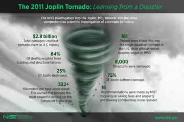
Informed by decades of experience studying disasters, a team of researchers at the National Institute of Standards and Technology (NIST) recognized that lessons from Joplin could have wide-reaching impact and leaped at the opportunity to closely examine the event. Their nearly three-year technical investigation into the event, supported by the National Oceanic and Atmospheric Administration (NOAA), uncovered vulnerabilities in emergency communications, building design practices and wind measurements. To address those weak spots, the team devised 16 recommendations entailing major improvements to various guidelines, building codes and standards.
Today, nearly a decade after the tragedy in Joplin, the dedicated efforts of NIST and other organizations to follow up on these recommendations have made significant headway in protecting life and property from tornadoes.
The experts conducted their investigation of the Joplin tornado under the National Construction Safety Team Act (NCST), which grants NIST and its teams the authority to access disaster sites, subpoena evidence and take other actions. Learn more about NCST.
Emergency Communication Is Key
Four NIST researchers — three engineers and one social scientist — were on the ground in Missouri within two days of the tornado, but severe weather still lingered.
Marc Levitan, the lead investigator, and Erica Kuligowski, a NIST sociologist and fire protection engineer at the time, were driving along the highway when they heard a distinct tone. Their NOAA weather radio — a special radio that can receive NWS alerts and warnings — told them a tornado was on the ground nearby, in the town of Sedalia.
Knowing they were vulnerable on the road, the pair quickly sought refuge.
“I typed ‘college’ into my GPS since those campuses typically have more robust structures, and we found a small college only a few miles away. We were right in the tornado’s projected path, so we high-tailed it,” Levitan said.
The pair sheltered in the basement of a college science building until the threat had passed.
The two had a close call, even though they had a NOAA radio on hand and took immediate action. That wasn’t the case for some Joplin residents who, just days earlier, were caught in the whirlwind. The NWS’s warning for the entire city clocked in at 17 minutes before the tornado touched down, allotting residents several minutes more lead time than the average for the nation. And the city engaged its siren system twice. So why were so many people caught in the line of fire? To find out, Kuligowski and her colleagues engaged with town officials and spoke to as many survivors as they could meet.
“I walked through neighborhoods and visited some tents that FEMA put up. I went from person to person and asked about what happened that day. How did the tornado affect them? What emergency communications did they get, and how did they respond?” said Kuligowski, now a Vice-Chancellor’s Senior Research Fellow at RMIT University in Australia.
NIST investigator Erica Kuligowski and others spoke to 140 survivors of the Joplin tornado, including a woman whose home was almost entirely leveled apart from the basement.
One of the key insights Kuligowski gleaned from 140 interviews was that the city audibly tested its sirens on a weekly basis. That, combined with the already high false-alarm rate inherent to tornado warnings (a national average of 74%), fueled a distrust in the siren system. Many of the survivors who received false alarms or heard tests in the past expressed they felt there was likely no real threat.
A storm just north of town, unrelated to the Joplin tornado, prompted an initial tornado warning and round of sirens, adding to the confusion. Two waves of sirens sounding in quick succession was not common, leaving many uncertain as to what it meant. Some people wondered whether it was an all-clear. And as the sirens were only meant to be heard outdoors, some residents indoors did not receive any indicators that a tornado was inbound.
Most of the survivors searched for evidence of a tornado with their own eyes. But much of the local news coverage at the time was fixed on the northern storm, and to make matters worse, a curtain of heavy rain hid the tornado from sight.
Alas, most people continued about their business, only grasping the grim reality once the tornado was almost upon them.
The investigators found no nationally accepted standards for sounding public sirens. There was a similar dearth of guidance for emergency communications in general. Once its investigation was complete, NIST called for these gaps to be filled.
“It's not easy to provide helpful information via these alerts, so I think it's important to standardize the systems,” Kuligowski said. “After the tornado, Joplin got together with other communities in the surrounding areas and they came up with a regional siren policy, so that if you go to the next town over it's not a completely different siren system.”
As part of the new policy, Joplin would only test nonaudible elements of its sirens, such as power, on a weekly basis and reduce the frequency of its full tests to once a month, Kuligowski said. To create guidance for the entire nation, NIST began a multiyear effort to review existing research on emergency responses and consult experts across several organizations, including the NWS and the Fire Protection Research Foundation.
In 2018, Kuligowski and others published guidance on developing effective alerts from outdoor sirens. The publication also covers technologies, such as mobile phones and social media, that can send alerts to users via push notifications based on their geographical location.
Among many other considerations, the guidance advises that messages identify the locations of nearby hazards, clarify that the alert is coming from an official source, and include an audible tone.
The National Fire Protection Association, a widely recognized codes and standards organization, incorporated NIST’s work on emergency communications into two of its standards, in 2017 and 2019.
Give Them Shelter
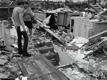
The whirlwind indiscriminately tore through Joplin’s building stock, destroying schools and stores and leveling entire neighborhoods. More than 7,400 residences made up the bulk of damaged buildings, about 40% of which were completely destroyed. Although it was a devastating result, the destruction came as no surprise given the tornado’s strength.
“If we're talking about the really strong tornadoes, it'd be economically prohibitive to have every building resist those, but that's why we have a shelter standard,” said James LaDue, an NWS meteorologist. “When you get to that intensity, we're talking about protecting life and limb.”
Joplin had no public shelters for its residents. And although specific spots in commercial buildings were designated as refuge areas, there is little evidence that they held up any better than other areas in those same buildings.
At the time of the Joplin tornado, neither the International Building Code (IBC) nor the International Existing Building Code (IEBC), two rulesets from the International Code Council (ICC) that form the foundation of U.S. state and local building regulations, required buildings to include storm shelters. And while the ICC published a standard in 2008 governing the design of tornado shelters in new buildings, it didn’t cover what to do in existing buildings, like the superstores, schools and other structures that were smashed in Joplin.
In response to this lack of guidance and the loss of life in Joplin, NIST pressed for the construction of more tornado shelters and shelter standards that consider existing buildings.
Based on proposals from the Federal Emergency Management Agency (FEMA), which offers its own guidance on safe rooms, and NIST, the ICC updated the two building codes. For areas that experience the most violent tornadoes, including parts of the Great Plains, Midwest and Southeast U.S., the IBC began requiring new critical facilities, including K-12 schools, 911 call centers, and fire and police stations, to include storm shelters in 2015. Then, 2018 updates to the IBC and IEBC expanded on previous versions by also requiring shelters inside new buildings and additions to buildings on existing school campuses.
As states and municipalities across the country have updated their requirements with the 2015 and later versions of the ICC codes, there has been an explosion in the number of tornado shelters being constructed. In many communities, such as Joplin, these new shelters are also open to the public. The state of Alabama has gone one step further, by requiring storm shelters in all new classroom and dormitory buildings on public college and university campuses.
Since NIST’s Joplin report was published in 2014, Levitan and others at NIST have worked closely with FEMA, the National Storm Shelter Association and the ICC, offering their data and technical expertise to help upgrade the shelter standard.
In late 2020, the ICC published a new version of its storm shelter standard with an expanded scope that covers designing and installing shelters in already standing structures. Among other updates are improved directions for testing how well building components resist blows from windborne debris and estimating the forces of impact from adjacent structures toppling over onto a shelter. FEMA also incorporated new information stemming from the Joplin investigation into its guidance.
Wind in Joplin Brings a Sea Change in Building Design
Effective emergency plans and shelters go a long way in protecting lives. That said, some buildings are key to keeping people safe. If high-occupancy buildings like schools are harmed, many lives could be at risk. And when essential facilities are damaged or destroyed, any community’s ability to recover quickly from a tornado or other event is severely reduced.
NIST found several buildings in those categories in a dire state. A fire station had its roof peeled off. Ten different schools were either severely damaged or completely collapsed, although fortunately, nobody was inside them that Sunday. A Walmart, a Home Depot and other commercial facilities were totally demolished.
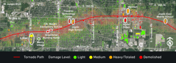
The Joplin tornado, moving roughly west to east, cut a 6-mile-long path through a densely populated are and was up to a mile wide in some places. The violent tornado indiscriminately tore through thousands of buildings, including Saint Johns Regional Medical Center (SJRMC), several schools, and big-box stores like Home Depot and Walmart.
The tornado struck several buildings of Saint John’s Regional Medical Center, one of two hospitals serving the area, shortly after it entered the city. The buildings’ concrete and steel frames held strong, but windows shattered, allowing fast-moving air and debris flying at high speed to pour in. Patients and staff huddled in the halls while glass, chairs, X-ray machines and a plethora of debris were tossed about, killing more than a dozen people.
The team of investigators assessed damage to the hospital and 24 other buildings throughout town using the NWS’s official tornado rating system, the Enhanced Fujita Scale. With this approach, they rated different instances of damage from EF0 to EF5 based on their severity. Theoretically, each level of damage is the outcome of a particular range of wind speed. At the lower end, EF0 damage is associated with speeds from 65 to 85 mph (105 to 137 km/h). And EF5, the most intense rating, translates to winds greater than 200 mph (322 km/h).
To figure out specifically how the buildings failed and what aspects of their design made them vulnerable, the investigators closely inspected their anatomy both in person and through design documents.
It was immediately apparent to the team that none were designed specifically for tornadoes, an expected outcome perhaps, as tornadoes were one of few hazards not yet considered in design standards and building codes at the time.
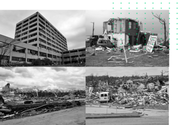
The Joplin tornado destroyed buildings of all kinds. When powerful winds struck a major hospital, nearly all its windows shattered, creating havoc inside (top left). Nearly 7,500 residences, such as the one in the top right photo, were damaged. Multiple big-box stores, including a Home Depot, held up poorly (bottom left). Nursing homes were not spared either. The roof of one nursing home completely detached, causing the building to collapse (bottom right).
But along with that harsh reality, the investigators could make out the glint of a small but significant silver lining. The most pummeled wreckage in Joplin earned an EF5 designation, but it was mostly confined to a small area near the spiraling core of the tornado. Further out, much lower ratings were prevalent.
“Over 70% of the area swept by the Joplin tornado had maximum winds in the EF0 to EF2 range,” Levitan said. “We can more easily design for that level of intensity.”
The team made it clear in its final report that it was time to create building codes and standards that address tornadoes. And in the years since, NIST has led the charge.
For hurricanes and other storms, building standards contain maps of the U.S. with different zones outlined, each associated with a wind speed relevant to that area. Engineers can find the location they plan to build in and its associated wind speed on the map. Then, based on that speed, the standard helps them calculate key aspects of their building’s design, such as the wind-induced pressures their walls and roof should be able to withstand.
With these standards, engineers don’t design for the worst possible hurricanes, but constructing buildings for the less intense events has still done a lot of good. Tornadoes have not received the same treatment, possibly because of the common perception that they are too rare and of an otherworldly intensity.
“With the exception of nuclear power plants and tornado shelters, we historically haven’t considered tornadoes in building design,” said Levitan. “People thought we’d all have to live and work in concrete bunkers if we did that.”
While lessons from Joplin flew in the face of this philosophy, a large amount of technical information was still needed to give engineers a fighting chance against tornadoes. As the lead agency of the multi-institution National Windstorm Impact Reduction Program, NIST has worked diligently over the past six years to bridge the gap.
NIST, supported by the engineering firm Applied Research Associates Inc., aimed to develop first-of-a-kind tornado hazard maps for the contiguous U.S., much like their hurricane counterparts, using more than 60 years of tornado records from the NWS as a jumping-off point. The records as they are, however, are not the most solid foundation.
The official tornado records only go back to 1950 and are less detailed before 2007, when the NWS adopted the EF Scale. The damage-based nature of the scale also means that tornadoes passing through rural areas may have come and gone without being recorded. To develop a more accurate assessment of tornado behavior, the researchers applied statistical methods to the available data, filling in the gaps with estimated wind speeds.
With the more robust dataset developed, the team sought to factor building size into the maps.
“Depending on the footprint of a facility, you may have greater or less risk of a tornado strike. A large hospital complex is much more likely to be hit than a single house, for instance,” said Long Phan, a NIST research engineer and member of the Joplin team.
Another key consideration during the development of the maps was time.
While it is highly unlikely for any particular building to be struck by a tornado in a given year, as time goes on, the likelihood only increases. The researchers designed the maps to offer tornado wind speeds with low odds of being surpassed during a building’s lifetime. For example, the wind speed for the design of a school is set so that there is an approximately 3% chance of that speed being exceeded over the course of the building’s assumed 50-year design life.
“The new maps were devised to provide a similar structural reliability for tornadoes as used in existing codes and standards for other types of windstorms,” said Levitan.
The maps, which will be featured in a forthcoming report, are only the first stop for building designers. Once they have their wind speeds in hand, they also need to account for other factors to estimate pressures and forces on the building and design their structures to endure them. Developing guidance for that part meant NIST and ARA had to obtain a better understanding of the unique ways in which tornadoes threaten buildings. They approached the problem from various angles.
By analyzing two decades' worth of existing mobile radar data, NIST wind engineer Frank Lombardo and others picked up on key traits of tornado winds at low heights relevant to buildings. Wind tunnel tests, in which researchers passed small-scale whirlwinds over miniature buildings, and computer models developed by ARA revealed insights into how much and where tornadoes applied pressure to buildings.
The researchers put together guidance based on their findings that prescribe methods for determining the tornado-induced forces that building components — the frame, the roof, the windows — should be designed to stand up to.
NIST proposed this guidance, along with the tornado hazard maps, to the American Society of Civil Engineers (ASCE) for inclusion in ASCE 7, a standard that is central to the nation’s building codes. In December 2021, ASCE released the 2022 edition of the standard, which includes the provisions for tornado-resistant design, applying specifically to high-occupancy structures and critical facilities.
Grasping at Wind
The closest radar to the Joplin tornado was stationed about 60 miles (97 kilometers) away, too far to capture the tornado’s wind speeds directly. NWS meteorologists relied almost solely on EF Scale ratings to estimate speed. But their ratings didn’t quite match up with other ratings, including NIST’s.
With the EF Scale, surveyors have their eyes peeled for 28 different kinds of structures or vegetation that serve as damage indicators. These include houses, apartment buildings and trees. One factor that likely added to the inconsistency among ratings is that any single damage indicator can only receive one rating.
A Walmart in Joplin, half of which was essentially flattened, illustrated this issue, as ratings varied greatly depending on which part of the building surveyors were looking at.
While on the ground, the NIST team noticed that solely relying on the list of damage indicators left many stones unturned, especially when it came to gauging EF5-level winds. Of the 28 indicators, only five — sturdy, well-engineered structures like buildings at Saint John’s Hospital — can capture the effects of EF5 damage. The tornado tossed heavy objects that were not on the EF Scale’s short list, such as manhole covers and tractor trailers, but could have held valuable information.
As Lombardo sifted through debris, he noticed particular kinds of indicators showing up time and time again — trees.
“We’re talking tens of thousands of trees that were down in Joplin. We got aerial imagery showing very distinctive pattens of treefall,” Lombardo said. “I thought, we can probably do something with this.”
Lombardo developed a computer model of the trees in Joplin and had a simulated tornado pass through them. He ran the simulation repeatedly at different wind speeds, checking how the digital treefall pattern compared with the aerial images each time until they matched up. The results gave the team a better idea of wind speeds throughout town than the EF Scale alone and were useful to other aspects of the investigation, like determining which winds led to building collapses or fatalities.
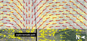
NIST investigators simulated the Joplin tornado’s impact on trees to gain insights about the strength and direction of the Joplin tornado’s winds. They cycled through tornadoes with differing characteristics in a computer model until the simulated treefall pattern (red) matched closely with the real treefall pattern (yellow) which was revealed through satellite images.
Upon completing its investigation, NIST resolved to spark an effort to fill in the gaps for wind measurements, bolstering the EF Scale and making other wind-estimating methods available. A potential standard devised by a NIST- and NWS-led committee of more than 100 meteorologists and engineers may accomplish exactly that.
Currently under review by the ASCE and the American Meteorological Society (AMS), the standard could add more damage indicators to the EF Scale and outline additional methods for gauging wind speeds, like the NIST treefall approach proposed by Lombardo, now an assistant professor in the Department of Civil and Environmental Engineering at the University of Illinois Urbana-Champaign. Another key feature may be a forensic approach based in part on NIST’s aforementioned research on tornado-resilient buildings.
“For tornado resilience, you figure out the required loads to build for given a certain wind speed. In our standard you reverse those equations. You figure out the wind speed given a certain state of damage. It's two sides of the same coin basically,” said LaDue, co-chair of the joint ASCE and AMS committee.
NIST has also come at wind measurements by supporting various institutions’ work through its disaster resilience grant program.
The combined effort to improve wind measurements could potentially set the stage for better designed buildings, more advanced forecasting and lower false-alarm rates.
The U.S. is the most the tornado-prone country, but with the progress made over the past decade in reshaping our codes and standards, we are now on the cusp of also being the most tornado-ready.
“NIST was a lonely voice in the beginning, saying ‘Yes, we can design for tornadoes,’ but over the years, others have joined in. It has been a complete paradigm shift,” Phan said.
Editor’s note: This story, originally published on May 21, 2021, was updated on Dec. 9, 2021, to reflect the publication of the 2022 edition of the building standard ASCE 7.
Summarized Recommendations From NIST’s Joplin Investigation
After investigating the Joplin tornado, NIST researchers issued 16 recommendations aimed at improving our understanding of tornadoes, the performance of structures and emergency communications. Here is a summary of these recommendations. (The full recommendations are available in the final report.)
- Develop and deploy technology to directly measure tornado wind speeds.
- Archive tornado data in easily accessible public databases.
- Develop tornado hazard maps for use in engineering design.
- Improve the U.S. tornado rating system and obtain adoption by the National Weather Service.
- Develop national standards for the tornado-resistant design of buildings.
- Develop performance-based methodologies for designing tornado-resistant building systems and components.
- Produce a standard for tornado shelters in existing buildings and install tornado shelters in many more buildings.
- Develop guidelines to help municipalities design public tornado-sheltering strategies.
- Develop guidelines for selection of best available tornado refuge areas in existing buildings.
- Prohibit gravel and other loose-aggregate roof coverings in tornado-prone regions.
- Develop requirements to protect enclosures of elevators, stairways and other egress systems in critical facilities.
- Create guidance for evaluating the tornado vulnerability of critical facilities.
- Develop national codes, standards and guidance for emergency communications, alerts and warnings.
- Deploy push technologies, including GPS-based mobile alerts, to transmit emergency information.
- Conduct research to enhance public risk perception and response during emergencies.
- Develop technology capable of relaying the probability of tornado threats in space and time.