
Official websites use .gov
A .gov website belongs to an official government organization in the United States.
Secure .gov websites use HTTPS
A lock (
) or https:// means you’ve safely connected to the .gov website. Share sensitive information only on official, secure websites.
- Earth-observing satellites can use new measurements of the Moon’s brightness as a benchmark to ensure that they are recording light from our planet’s surface accurately.
- Reliable measurements of the light from our planet can help industries from agriculture to meteorology to mining.
- The new data represents a tenfold improvement over the data that satellite sensor engineers used previously.
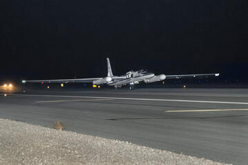
NASA’s ER-2 taking off with the air-LUSI moonlight collection equipment on board.
Weather forecasting, mineral prospecting and farming all could improve from a trove of data the National Institute of Standards and Technology (NIST) recently gathered about moonlight, late at night and far above the clouds.
NIST’s measurements of the Moon’s brightness — 10 times more accurate than previously available data — are a valuable commodity for engineers, who can use the data to calibrate the visual sensors aboard Earth-observing satellites. Proper calibration can help ensure that these satellites are accurately recording the actual amounts and colors of light from the ground, water and vegetation far below. NIST obtained its new set of moonlight measurements by deploying its equipment on a high-altitude NASA aircraft.
“Our goal with this data release is to help the satellite industry develop better models of lunar irradiance,” said Joe Rice, the NIST group leader for the project. “Using the data will help ensure that scientists have a more accurate understanding of what images of Earth from orbit actually mean.”
Before a satellite can take reliable visuals of the planet, the satellite’s sensors need to be calibrated to make sure they are recording accurate data. Without this vital step, a sensor might indicate that a swath of territory is a different shade or intensity of color than it really is, leading farmers or prospectors to base their decisions on the inaccuracy.
Sometimes engineers calibrate satellites before launch, but it costs time, money and effort, partly because a rocket ride to space puts a lot of stress on a satellite. The acceleration of launch subjects a satellite to forces that are the equivalent of many times Earth’s gravity, and powerful vibrations during flight shake and rattle the instruments vigorously, potentially undoing the effects of the calibrations.
Larger satellites might carry devices that allow them to self-calibrate after launch, but such devices add weight and use up valuable real estate. And not all satellites are large enough even to have this option. In cubesats, built from a few cubic modules that are 10 centimeters to a side, volume is at a premium.
An easier approach is to use light from the Moon, which has reflectance properties that change very little over time and therefore offers a consistent benchmark. From time to time, a satellite sensor may take an image that includes the Moon, and the sensor can be calibrated to the different wavelengths of light reflecting from its surface.
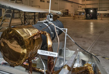
Land-based telescopes have trouble getting accurate details of the Moon’s irradiance because our planet’s constantly changing atmosphere introduces too much uncertainty. So NIST physicist John Woodward and his colleagues arranged to mount a special telescope on a NASA ER-2 aircraft that flies at 70,000 feet, or 21 kilometers, which is higher than 95% of the atmosphere. The mission, called the Airborne Lunar Spectral Irradiance Mission (air-LUSI), flew from NASA’s Armstrong Flight Research Center. After several years of engineering and test flights, the project began gathering data in 2022 and conducted its most recent measurements in early 2025.
The new dataset allows distinct improvements over previous lunar irradiance models, which were good at measurements that could show how a sensor’s performance was changing over time but made it difficult to know if and how the Earth itself was changing. The new data not only reduces the uncertainty inherent in ground-based data, but it is also directly tied to the International System of Units (SI), making it easier to apply.
“This dataset is 10 times more accurate than the data people previously had to use,” said Woodward. “It will permit a distinct improvement over the other ways we have calibrated satellites.”
The dataset, now available through NIST’s data portal, is in the netCDF format widely used by the scientific community. It contains irradiance measurements along with the time, location and uncertainty associated with them. It includes information about the instrument NIST used, to help people make useful comparisons with their own sensors’ performance. Also available are details of how to read and display the data along with guidance to help users get started working with it.
Woodward said he was optimistic about the future use of the dataset. One reason is because accurate, consistent calibration among satellites would enable observers on the ground to spot trends more effectively.
“Satellites are expensive national assets, and you want them to be as useful as possible,” he said. “If we calibrate them using the Moon, satellite observations could become more valuable. For example, we’d know whether the color of farmland had changed because rain had improved crop health, rather than because two different satellites took two different images at different times.”
The air-LUSI project is a collaboration between scientists and engineers from NASA, NIST, the U.S. Geological Survey, the University of Maryland Baltimore County, and Ontario’s McMaster University.