
Official websites use .gov
A .gov website belongs to an official government organization in the United States.
Secure .gov websites use HTTPS
A lock (
) or https:// means you’ve safely connected to the .gov website. Share sensitive information only on official, secure websites.
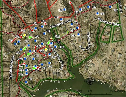
This map, detailing some of the behavior of a 2011 wildland fire outside Amarillo, Texas, demonstrates how NIST?s post-fire electronic data collection system can yield greater insight into the dynamics of a wildfire than traditional methods. Red arrows show movement and direction of the fire while green arrows represent the jumping of burning embers between structures. Other symbols show structures as either destroyed, damaged or spared by the fire.
A new report by the National Institute of Standards and Technology (NIST) describes how researchers analyzed a major 2011 Texas wildland fire using a rigorous and scientifically based post-fire data collection approach, a system they believe will lead to improved defensive measures and strategies for significantly reducing structural damage and property loss.
In February 2011, three fires raged through suburban areas outside of Amarillo, Texas, at the wildland urban interface (WUI), the area where residential communities and undeveloped wildlands meet. The fires destroyed 70 homes, burned more than 10,000 hectares (25,000 acres) of land and caused nearly $6 million in property damage. What made these events different from other WUI fires was that—for the first time in an actual fire situation—researchers used a two-tiered electronic data collection methodology developed by NIST to assess post-fire conditions. This resulted in the most extensive amount of information acquired to date in the aftermath of a WUI fire, approximately 163 gigabytes of data and more than 29,000 photographs.
The massive amounts of data collected and analyzed were used in two separate NIST reports. The first, issued in July 2011, provided a reconnaissance overview of all three Amarillo WUI fires and identified the technical factors that may have influenced whether impacted structures were damaged or destroyed by the event, or survived. The latest study is NIST Technical Note 1909: 2011 Wildland Urban Interface Amarillo Fires Report #2—Assessment of Fire Behavior and WUI Measurement Science. It features a comprehensive documentation and analysis of one of the blazes, known as the Tanglewood Complex Fire, including:
- A detailed timeline of the fire's movement and spread;
- A record of the types and construction of structures that were affected or endangered by the fire;
- A description of topographic characteristics and fuel sources (including vegetation and structural elements such as fences);
- Observations of the fire's behavior; and
- An assessment of defensive measures in place before the fire.
The first tier of the NIST WUI data collection system used in the Amarillo study is a survey for recording broad observations of damage across the entire fire perimeter (the outer edge or boundary of a fire). This provides input for the second tier of data collection, which includes a kit with tools designed to capture the specific details needed for developing a precise fire timeline, building computer models to study a fire's behavior in depth, and most importantly, identifying and assessing all of the factors that determine the response of different structures to a WUI fire (such as the types and amounts of combustibles on or around a structure).
"The level of detail that can be obtained with our data collection system is significantly greater than traditional procedures that focus simply on the number of structures damaged or destroyed, without taking into account the underlying factors that actually cause the destruction," says NIST fire protection engineer and Amarillo study team leader Alex Maranghides. "Gathering as much data as possible in this strategic manner gives us unprecedented insight into how and why structures respond to WUI fires—and that knowledge could help us build more fire-resilient communities in the future."
The Tanglewood Complex post-fire data collection and analysis resulted in a number of technical findings. Perhaps the two most interesting, Maranghides says, are that destroyed structures provide less information about a WUI fire than damaged ones, and that mapping all of the potential WUI fire hazards in a community leads to better defensive strategies than if only selected hazards are addressed.
"To illustrate why damaged structures yield more valuable data, imagine that your deck ignites during a WUI fire and is extinguished by first responders," Maranghides explains. "We now know that the deck material is vulnerable and we can take steps to remedy that hazard. If the whole property is destroyed, we lose that insight."
As for the second key finding, Maranghides says that current WUI fire hazard rating systems rely on limited technical information to develop weighted ratings. "For example, if you replace your roof with a more fire-resistant version, a weighted scoring system will rate your home as 'safer' when other unconsidered factors, such as the types and locations of vegetation, may pose a greater danger in a WUI fire," he explains. "We have to know where the real vulnerabilities are to provide real protection and not be lulled into a false sense of security."
NIST's work on WUI fires is part of its ongoing programs for enhancing disaster resilience by reducing the risks of fires, earthquakes, windstorms and coastal inundation on buildings, infrastructure and communities, including facility occupants/users and emergency responders. The Amarillo WUI fire study was conducted in collaboration with the Joint Fire Science Program (U.S. Department of the Interior and the U.S. Forest Service) and the Texas A&M Forest Service.