
Official websites use .gov
A .gov website belongs to an official government organization in the United States.
Secure .gov websites use HTTPS
A lock (
) or https:// means you’ve safely connected to the .gov website. Share sensitive information only on official, secure websites.
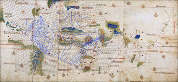
The source of the peculiar accuracy of certain medieval maps known as Portolan charts has been a mystery that has stumped scholars for hundreds of years. In this presentation I will describe the surprising accuracy of these maps, produced from 1270-1550, using
Anyone outside NIST wishing to attend must be sponsored by a NIST employee and receive a visitor badge.
For more information, contact Kum Ham at 301-975-4203.
Colloquia are videotaped and available in the NIST Research Library.
John Hessler
Fellow, Royal Geographical Society
Geography and Map Division
Library of Congress