
Official websites use .gov
A .gov website belongs to an official government organization in the United States.
Secure .gov websites use HTTPS
A lock (
) or https:// means you’ve safely connected to the .gov website. Share sensitive information only on official, secure websites.
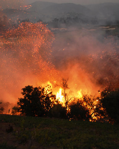
A wooded area aflame during the 2007 Witch Creek/Guejito wildfire in Southern California. A new report from NIST looks at the fire's impact on structures in one community based on their pre-fire exposure risk to direct fire contact and embers (both seen in the photo).
A recent study of one of California's most devastating wildland fires by the National Institute of Standards and Technology (NIST) and the U.S. Forest Service (USFS) strongly suggests that measures for reducing structural damage and property loss from wildland urban interface (WUI)* fires are most effective when they are based on accurate assessments of exposure risks both for individual structures and the community as a whole.
The report also describes how the NIST-USFS WUI Hazard Scale provides a state-of-the-art tool for making such assessments and how that data could be linked to improved building codes, standards and practices that will help communities better resist the threat of wildfires.
The Witch Creek/Guejito WUI fire (commonly known as the Witch Fire) was the largest of a series of wildfires that began burning across Southern California on Oct. 20, 2007. It affected areas north and northeast of San Diego, starting in Witch Creek Canyon near Santa Ysabel and quickly spreading westward toward the coast because of strong Santa Ana winds. The Witch Fire burned some 80,000 hectares (nearly 200,000 acres), destroyed more than 1,600 structures, caused an estimated $1.8 billion in property damages and cost $18 million to fight. It also was responsible for two civilian deaths and 39 firefighter injuries.
A NIST-USFS WUI team worked in collaboration with the California Department of Forestry and Fire Protection (CAL FIRE) and the City of San Diego to collect post-incident data within the Witch Fire perimeter. The team focused its effort on The Trails development at Rancho Bernardo, north of San Diego. There were 274 homes in The Trails, with 245 within the fire perimeter. Seventy-four homes were completely destroyed and 16 were partly damaged. Field measurements made by the NIST team included structure particulars, specifically roof type; proximity of combustibles to the structure; and damage to wildland and residential vegetation. Documentation included more than 11,000 photographs.
The data collected and analyzed were used in two separate NIST-USFS reports. The first, issued in 2009, created a detailed timeline of the Witch Fire, tracked its impact on the community, and documented defensive actions taken by homeowners and first responders. The latest study evaluates the effectiveness of those mitigation techniques addressing exposure risks—as defined by the WUI Hazard Scale—associated with direct fire contact and ignition by embers.
"This is the first time anyone has looked at wildfire impact by evaluating pre-event exposure risks throughout an entire community and how those risks affected the defensive actions that were in place," says Alexander Maranghides, lead author of both Witch Fire reports.
What the researchers found was that the majority of defensive strategies used in The Trails were effective and that the level of effectiveness was correlated to fire and ember exposure. Damage and destruction were more prevalent in structures assessed by the WUI Hazard Scale as having been at highest risk from fire and embers. Accordingly, defensive actions were more than twice as effective in saving structures in low-exposure sections of the community as compared to high-risk areas.
Maranghides says that a pre-event knowledge of exposure risks also may be helpful in determining how firefighters attack a WUI fire. "Our data show that it's probably best to fight fires in low-exposure areas because there's a greater chance that they can be suppressed and with less danger to the crews," he explains. "It may be better to sacrifice structures in high-exposure areas than risk the loss of firefighter lives in unwinnable situations."
Useful links:
- The newest study: A. Maranghides, D. McNamara, W. Mell, J. Trook and B. Toman. A Case Study of a Community Affected by the Witch and Guejito Fires: Report #2 – Evaluating the Effects of Hazard Mitigation Actions on Structure Ignitions. NIST Technical Note 1796 (2013) at http://nvlpubs.nist.gov/nistpubs/TechnicalNotes/NIST.TN.1796.pdf
- Announcement of the NIST/USFS WUI Hazard Scale: "NIST and Forest Service Create World's First Hazard Scale for Wildland Fires," Dec. 5, 2012
- First NIST study of the Witch fire: "NIST Study Offers First Detailed Look at the Progress of a Wildland-Urban Fire," June 16, 2009.