
Official websites use .gov
A .gov website belongs to an official government organization in the United States.
Secure .gov websites use HTTPS
A lock (
) or https:// means you’ve safely connected to the .gov website. Share sensitive information only on official, secure websites.
Unmanned Aerial Vehicles for Wildland-Urban Interface Fires
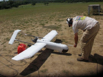
NIST with US Forest Service (USFS) have invested in the development of instrument packages and measurement science to enable the successful scientific use of these aerial platforms in the Wildlands and at the WUI. These instrumented UAVs with their supporting ground station allow for the real-time collection of aerial-based data including infrared images of firelines and wind velocity and direction. Each aircraft has a wingspan of 8.5 feet, take-off weight of 35 pounds, a flight duration of up to 10 hours /400 miles, and a maximum airspeed of 60 knots. The UAVs enable the development of reliable fire behavior prediction tools and the evaluation of hazard mitigation solutions such as fuel treatments in the wildlands or the hardening of structures within the community.
Scientific Opportunities/Applications
The data generated are used to 1) characterize fire behavior in wildland fuels, 2) document communities damaged by Wildland Urban interface (WUI) fires, and 3) support future incidents. Initially in prescribed burn settings, the characterization work is critical to enable the development of reliable fire behavior prediction tools. The damage documentation work supports the NIST/USFS WUI fire data methodology framework. The NIST/USFS methodology used field data, aerial imagery and technical discussions with first responders to reconstruct WUI fire events. This accurate and precise reconstruction enables the reliable quantification of WUI fire behavior. Specifically the methodology enables the evaluation of hazard mitigation solutions such as fuel treatments in the wildlands or the hardening of structures within the community. Work that supports future incidents will be aimed at supporting the needs of Incident Commanders. Metrology developments have enables our UAVs to discriminate flaming combustion from "hot" consumed fuels. This information can provide the Incident Commander with valuable situational awareness both on the location of the fire front and on mop-up and identification of hotspots. Before the safe deployment of UAVs in incidents, the National Incident Management System (NIMS) protocols need to be updated to include UAVs.
Usage Information
Access Information
Aircraft are operated in accordance with Field safety operations procedures (FSOP) contained in Certificate of Authority issued by the Federal Aviation Administration 2011-CSA-63 and manufacturers manual (MLB Super Bat) dated 04/29/12 amended 05/08/2012. Industry, university, and government representatives are encouraged to contact Mr. Maranghides to discuss collaborative use of these aircraft on a collaborative or independent cost reimbursable basis, with extensive restrictions. For safety reasons, EL staff supervise the use of the aircraft.