
Official websites use .gov
A .gov website belongs to an official government organization in the United States.
Secure .gov websites use HTTPS
A lock (
) or https:// means you’ve safely connected to the .gov website. Share sensitive information only on official, secure websites.

On February 26, 2017, DSCOVR EPIC captured an annular solar eclipse over South America.
At Earth from a Distance
NIST's Role in Observing Our Planet from Space
Quick, think of a four-letter name beginning with “N” for a federal agency involved in space science. Though NASA or NOAA would rightfully pop into mind first, crossword puzzle aficionados should know that NIST would be a correct answer as well—because the National Institute of Standards and Technology has been an integral part of readying technology for blastoff for decades.
For the past 24 years, a sizable portion of our nation’s space effort has involved missions to observe—and measure—phenomena on our own planet. The need for better data on how Earth responds to variations in the sun's output—as well as to human influences—has inspired multiple series of satellites. Next up is DSCOVR: the Deep Space Climate Observer, a partnership between the National Oceanic and Atmospheric Administration (NOAA), NASA and the U.S. Air Force.
Slated for launch on Feb. 8, 2015, DSCOVR contains two NASA-funded instruments that got a big helping hand from NIST. One, called NISTAR, was conceived at NIST. It will systematically track the Earth’s radiation budget—measuring whether our planet retains as much, more or less solar energy than it radiates back into space.
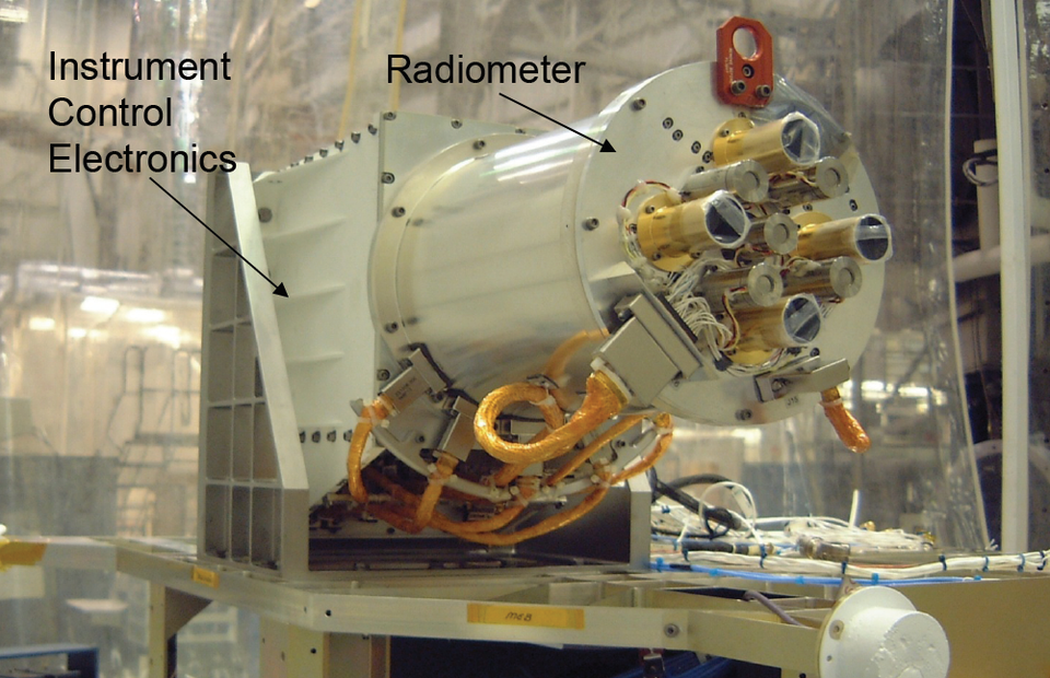
The DSCOVR Mission's NISTAR—the NIST Advanced Radiometer—will measure the Earth’s radiation budget, or whether our planet’s atmosphere is retaining more or less solar energy than it radiates back to space.
Sensor Calibration—a NIST Specialty
Earth-observing satellites scrutinize particular aspects of the planet—the oceans, the land, cloud cover—but regardless of specialty, their sensors all measure light reflected or emitted from the Earth. These sensors typically measure light at visible, infrared and ultraviolet wavelengths to obtain information that is difficult to measure from the ground, such as overall snow and ice cover, the health and extent of vegetation, and levels of ocean chlorophyll. These details provide important information on how, for example, the planet is responding to greenhouse gases, aerosols, clouds and other components of the atmosphere.
A crucial step in launch preparation is instrument calibration, an essential requirement for ensuring that data captured in space are trustworthy. This is where NIST, the nation’s measurement authority, comes in. Satellites from many countries gather information about our planet, and ensuring U.S. satellites make light measurements with values traceable to the international system of units (SI) enables valid comparisons with observations from other sources. Calibrating remote-sensing instruments to irrefutable standards helps provide an unambiguous picture of our environment.
Companies that build instruments for space missions often turn to NIST to ensure that their sensors will make accurate measurements once aloft. In practice, this means that scientists such as Joe Rice of NIST's Sensor Science Division (SSD) have to spend a lot of time calibrating these instruments with special light sources.
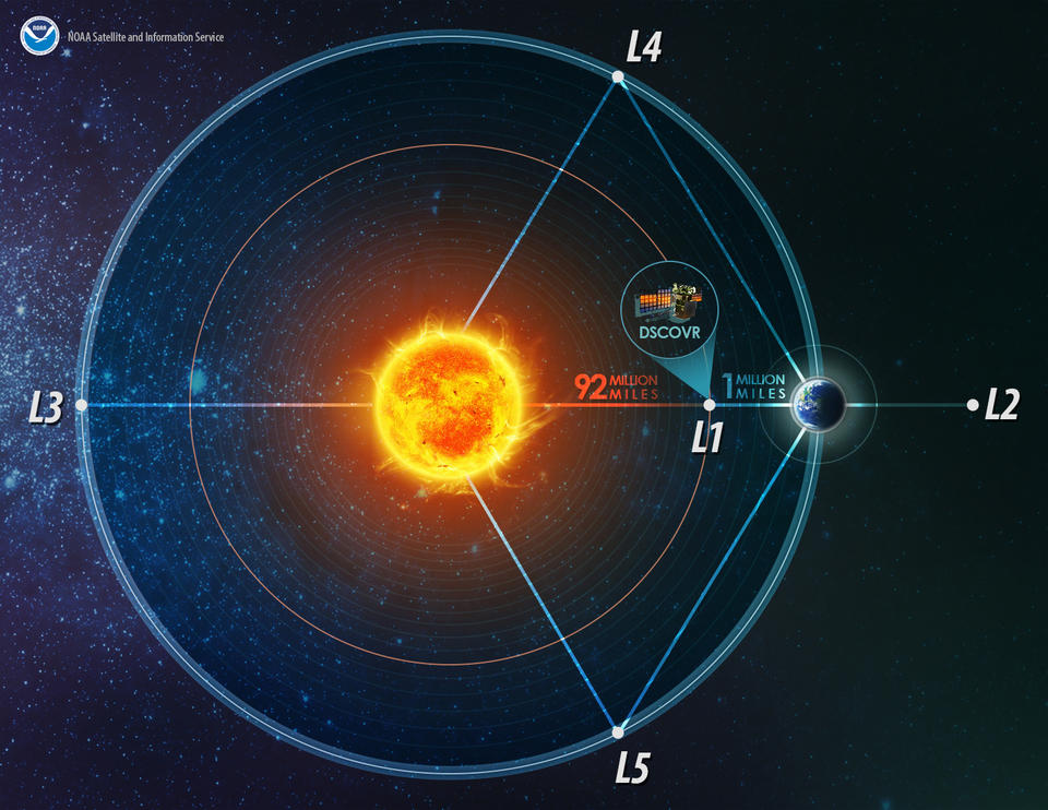
Lagrange Points of the Earth-Sun system (not drawn to scale).
"Aerospace companies calibrate these satellite instruments, which can be thought of as similar to cameras, by pointing them at standard light sources to check how each pixel is responding," Rice says. "For this sort of radiometric calibration, they would need to be sure they can trust their knowledge of the amount of light the standards put out. So they might send us their standard light sources, which we carefully compare at many wavelengths to NIST standard light sources.”
Validating the company's own calibration standards and methods for its in-house measurements saves time and money for the contractor and the government. But, sometimes more direct assistance is necessary—for more detailed characterization of a sensor, for example, or to help train another organization’s researchers. NIST scientists often travel to companies to help them assess the validity of their testing methods and equipment, or even perform the calibration themselves. So far, NIST teams have performed validations in Japan and France as well as the United States.
NIST’s involvement with satellite sensors dates back to the 1960s, when NASA and NOAA were developing technology for weather satellites. NIST—known at that time as the National Bureau of Standards, or NBS—worked with both agencies to develop standard light sources and detectors for calibrating optical sensors to reduce uncertainties in satellite data. But while NIST supported many projects, such as helping NOAA figure out problems with its TIROS series of weather satellites, there was no formal ongoing collaboration.
NIST’s support for earth observation missions expanded in 1991. In April of that year, NIST physicist Carol Johnson began attending meetings for the group calibrating the instruments on the Earth Observation System (EOS), an ongoing program to provide long-term observations of the planet’s air, land, water and biosphere. With DSCOVR’s launch, EOS will include more than two dozen active satellites.
“Prior to that meeting, we had helped NOAA figure out problems with some weather satellites, but they were individual requests,” says Johnson, also of SSD. “The EOS program initiated a long-term collaborative effort.”
Since 1991, NIST has helped NASA, NOAA and their aerospace company partners with instrument calibration on a number of missions, starting with 1997’s Sea-viewing, Wide Field-of-view Sensor (SeaWiFS) mission, which gathered data on ocean color. NASA, in turn, helped NIST develop SIRCUS, a calibration system that uses lasers instead of light bulbs.
“Because we can finely tune the power and wavelength of laser light, SIRCUS is great for precise calibrations,” says Keith Lykke, leader of SSD’s Laser Applications Group. “It’s effective when you need to calibrate large-aperture instruments like big telescopes and satellite systems, so it’s been in high demand for the past few years.”
For example, NASA is funding NIST to use its portable version of the laser-based apparatus—dubbed the Traveling SIRCUS—to calibrate and characterize the Visible Infrared Imaging Radiometer Suite (VIIRS) sensor on the first satellite in the next generation of polar-orbiting weather satellites.
Demand for NIST calibration has led to NIST involvement in numerous missions, some of which are still in the planning stages.
Earth Observation Missions: The NIST Assist List
Satellites and Sensors in Current Operation
- Suomi-National Polar-orbiting Partnership (S-NPP) Visible Infrared Imaging Radiometer Suite (VIIRS)
- Landsat 7 and the Landsat Data Continuity Mission (LDCM), the latest two in the Landsat series of Earth-imaging satellites
- Earth Observing System (EOS), a series of two dozen satellites that provide long-term data
- Orbiting Carbon Observatory-2 (OCO-2), monitors atmospheric carbon dioxide
- Sentinel-2, a pair of European Space Agency satellites that monitors rapid changes in land surface conditions such as vegetation during the growing season
Planned / Possible Future Missions and Sensors
- Geostationary Operational Environmental Satellite R-Series (GOES-R), the latest in the GOES series of weather satellites
- Stratospheric Aerosol and Gas Experiment (SAGE-III), to be mounted onto the International Space Station to observe atmospheric gases; launch planned for 2016
- Joint Polar Satellite System (JPSS), weather satellite series; first launch planned for November 2016
- Ocean Radiometer for Carbon Assessment (ORCA), sensor will observe ocean color for proposed PACE and/or ACE missions
- Climate Absolute Radiance and Refractory Observatory (CLARREO), a proposed multi-satellite mission to observe climate change
- Hyperspectral InfraRed Imager (HyspIRI), a proposed mission to observe how ecosystems respond to human land management and climate change
DSCOVR—A Bit More Special Than Usual
Among these missions, DSCOVR warrants special mention, and not only because it is one of the few space probes ever to orbit at Lagrangian point L1, about 1.5 million kilometers (almost 1 million miles) away from Earth. (At this spot, the gravity of the sun and Earth are equal, so the DSCOVR craft will move very little in relation to Earth, giving it a constant view of the planet’s sunlit side.) What makes DSCOVR unique from NIST’s perspective is the fact that it is the first Earth-observing space mission to carry an instrument that NIST scientists not only calibrated, but had a hand in designing as well.
NISTAR (the NIST Advanced Radiometer) will measure the total amount of energy the sunlit side of Earth reflects and emits between the wavelengths of 0.2 and 100 micrometers—visible light plus a substantial portion of the infrared and ultraviolet bands. Together with photographic images from DSCOVR’s larger instrument, the NIST-calibrated Earth Polychromatic Imaging Camera (EPIC), NISTAR’s data will help scientists create better climate models. When the Scripps Institution of Oceanography wanted a radiometer aboard DSCOVR to complement the EPIC camera, they looked to NIST for help.
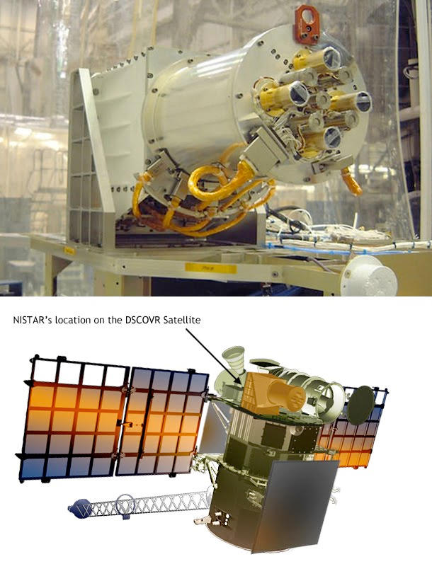
Top: DSCOVR Mission's NIST Advanced Radiometer. Bottom: Location of NISTAR on the DSCOVR satellite (in orange).
“Steve Lorentz (a former NIST staff member) and I got involved with NISTAR more than a decade ago because it’s of a class of radiometers that we were familiar with,” Rice says. “Scripps was in charge of the science payload. They asked us for assistance, and we agreed to help design it.”
A contractor, Ball Aerospace and Technology Corp., was tasked with most of the construction work, though Rice says the instrument concept, test software development, and calibration method (using SIRCUS) were all NIST’s.
Results of the calibration indicate that NISTAR will achieve better than the 1.5 percent absolute accuracy required for the mission.
"NIST will be able to approximately separate the Earth's radiant power from reflected solar energy by making measurements in three overlapping wavelength bands. This will be an important contribution to the Earth climate debate," says Adam Szabo, DSCOVR Project Scientist at NASA's Goddard Space Flight Center in Greenbelt, Md.
Sensing the Future
Proud though NIST can be to have a homegrown instrument on a space mission, Rice says NISTAR is an outlier. SSD plans to continue focusing on developing its calibration capabilities—not only for calibrating instruments prior to launch, but also helping instruments maintain their calibration while in orbit.
For example, some planned satellite missions will make frequent observations of ocean color, determined by phytoplankton and other constituents whose concentrations are affected by the environment. These satellites will need to calibrate their sensors from orbit using special instrumented ocean sites such as the Marine Optical Buoy (MOBY) stationed off Hawaii.
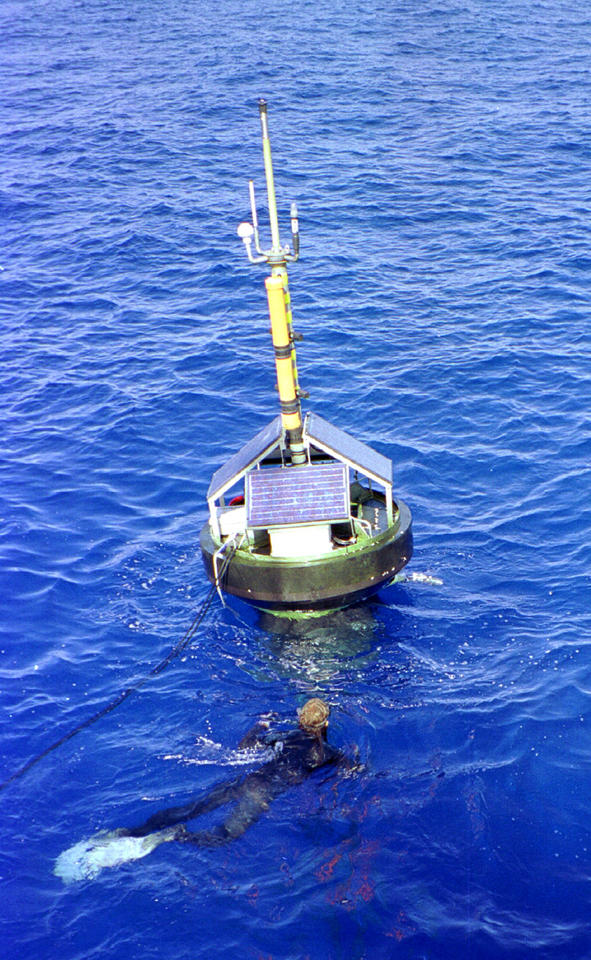
The Marine Optical Buoy (MOBY) near Hawaii takes frequent ocean color measurements that are used to adjust DSCOVR’s radiometric scale.
“MOBY takes ocean color measurements timed with the satellite overpasses and this information is used to adjust the satellite’s radiometric scale,” Johnson says. “This month, we are continuing in our series, which began in 1994, of validating the NIST-traceable sources that are used to calibrate MOBY.”
NIST is also working with NASA and many other institutions to develop and test techniques for monitoring urban areas’ emissions and determining their sources, a program called the Megacities Carbon Project. One of the goals, according to NIST’s James Whetstone, is to use the project’s data to calibrate satellites.
“We’d like to see whether we can use cities like Los Angeles as frequent calibration points for greenhouse gas observing satellites,” says Whetstone, who leads the NIST-wide research program on greenhouse gas and climate science measurements. “Once calibrated, if your satellite goes over areas that don’t have ground-based instruments nearby, you can have greater confidence in the satellite’s gas measurements for locations anywhere on the globe.”