
Official websites use .gov
A .gov website belongs to an official government organization in the United States.
Secure .gov websites use HTTPS
A lock (
) or https:// means you’ve safely connected to the .gov website. Share sensitive information only on official, secure websites.
FY2009: Disaster Resilient Structures and Communities
Challenge
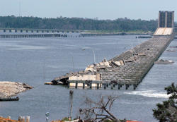
The disaster resilience of our physical infrastructure and communities today is determined in large measure by the building standards, codes, and practices used when they were built. With few exceptions, these are oversimplified and inconsistent with current risk assessments. As construction and rebuilding costs continue to rise, there is increasing recognition of the need to move from response and recovery to proactively identifying and mitigating hazards that pose the greatest threats.
Proposed NIST Program
NIST and the National Oceanic and Atmospheric Administration (NOAA) have coordinated their programs in this area. Initiative funding in FY 2009 will allow NIST to develop:
standard methods to predict losses, evaluate disaster resilience, and estimate cost-to-benefit of risk management strategies at the community and regional scales as opposed to the individual building scale;
decision support tools to modernize standards, codes, and practices consistent with the risk;
a validated "computational wind tunnel" for predicting extreme wind effects on structures; and
risk-based storm surge maps to be used in designing structures in coastal regions and an improved hurricane intensity classification scale.
In addition, the funding will allow expansion and acceleration of research results for projects begun with funding in FY 2007 on:
prediction of fire hazards at the wildland/urban interface; and
improved tools for designing and constructing earthquake-resistant structures.
Expected Impacts
A 2005 National Institute of Building Sciences study found that a dollar spent on hazard mitigation saves society an average of $4, with positive benefit-cost ratios for all hazard types studied. This initiative will improve community resiliency and protect property and lives through:
reduced risk from hurricanes and windstorms, fires at the wildland/urban interface, and earthquakes;
science-based tools for more robust hazard mitigation assessments, better local and private resource allocation decisions, and guidance to communities for responding to large-scale wildland/urban fires;
both short- and long-term improvement in seismic, wind, and fire provisions for model building codes; and
technical resources such as guidelines, manuals, and evaluation of mitigation technologies that enhance structural engineering practice.